Mission Gallery
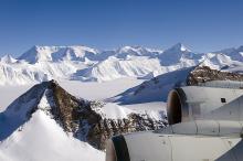
View of the Ellsworth Mountains during today's mission
An IL-76 parked on taxiway "Echo" in Punta Arenas

The DC-8 on the ramp in Punta Arenas getting ready for science flight #12

Trajectory map of today’s science mission

Trajectory map of today’s science mission

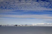
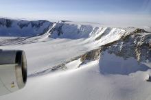
View of the Pensacola Mountains
View of the Pensacola Mountains

View of the Antarctic Peninsula from high altitude

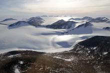
Mountains along the Hobbs Coast in Marie Byrd Land
Mountains along the Hobbs Coast in Marie Byrd Land
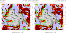
Trajectory map of today’s science mission

Trajectory map of today’s science mission

Digital Mapping System image mosaic of Pine Island Glacier rift

Digital Mapping System image mosaic of Pine Island Glacier rift
Trajectory map of today’s science mission

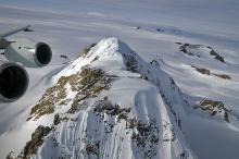
Ellsworth Mountains, Antarctica

Ice fall in the Ellsworth Mountains, Antarctica

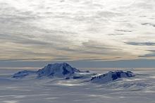
View of the Ellsworth Mountains with the Vinson Massif and Mount Vinson

View of the Ellsworth Mountains with the Vinson Massif and Mount Vinson
View of the Ellsworth Mountains and Sentinel Range

Map of today’s science mission

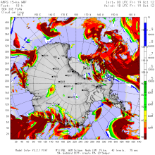
AMPS model forecast
Today's DC-8 trajectory over the Bellingshausen Sea

View of the Shackleton Range, Antarctica
Infrared satellite composite image

AMPS model forecast
Trajectory of today’s science mission over Recovery Glacier

DC-8 inflight towards 1st Antarctic flight of the season

Dan and Jhony in PA 2012

NASA DC-8 in Punta Arenas 2012 - New Airport Tower

Disclaimer: This material is being kept online for historical purposes. Though accurate at the time of publication, it is no longer being updated. The page may contain broken links or outdated information, and parts may not function in current web browsers. Visit https://espo.nasa.gov for information about our current projects.