Mission Gallery
Data
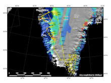
Figure 1: Today's trajectory in yellow and mission plan in red.
Infrared satellite image available before takeoff

DMS image of one of the start/end of the main survey grid.

DMS image of one of the start/end of the main survey grid.
Trajectory map of the 7 passes over the NRL ground site near Barrow.

Today's mission plan and P-3 trajectory.

IR satellite image before takeoff

Today's mission plan and P-3 trajectory.

Today's mission plan and P-3 trajectory.

DMS image of Vostok Station

DMS image of Vostok Station
Data collection over ICESat-2 cal/val site in TAM

Today's mission plan and P-3 trajectory.

DMS mosaic of crevasses on MacAyeal Ice Stream (formerly Ice Stream E)

DMS mosaic of crevasses on MacAyeal Ice Stream (formerly Ice Stream E)
Today's mission plan and P-3 trajectory.

Today's mission plan and P-3 trajectory.

Today's mission plan and P-3 trajectory.

Today's mission plan and P-3 trajectory.

DMS image mosaic of melt water channels

DMS image mosaic of melt water channels
DMS images of corner reflectors near Barrow

DMS images of corner reflectors near Barrow
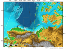
Today's P-3 trajectory over the Beaufort Sea

Infrared satellite image 4 hours before takeoff

DMS mosaic of sea ice in the Beaufort Sea

DMS mosaic of sea ice in the Beaufort Sea
Today's P-3 trajectory over the Beaufort Sea
Infrared satellite image 3 hours before takeoff

Today's P-3 trajectory over the Beaufort and Chukchi Seas

Disclaimer: This material is being kept online for historical purposes. Though accurate at the time of publication, it is no longer being updated. The page may contain broken links or outdated information, and parts may not function in current web browsers. Visit https://espo.nasa.gov for information about our current projects.