Mission Gallery
Map of Sea Ice - TanDEM-X B

Crescent Scarp

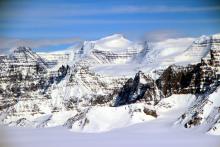
Triune Peaks

Icefall

Clifford Glacier

Map of South Peninsula A

Meltwater channels

Flank of ice sheet

Supraglacial lake

Map of Hiawatha Lakes

Kangerdlugssup icefall

Kangerdlugssup tributary

Half dome feature

Kangilerngata Sermia

Map of Jak-Eqip-Store

Sermeq Avagnarleq

Sarqardliup Sermia

Jakobshavn calving front

Jakpbshavn Glacier

Map of Thomas-Jakobshavn 01

Valley wall

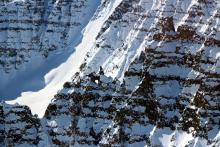
Knife edge ridge

Map of Penny 01

Belcher Glacier

Coast of Bylot Island

Fast ice edge

Map of Devon-Bylot

Daugard-Jensen Glacier

Mount Gunnbjorn
Rock arch and pinnacles
Disclaimer: This material is being kept online for historical purposes. Though accurate at the time of publication, it is no longer being updated. The page may contain broken links or outdated information, and parts may not function in current web browsers. Visit https://espo.nasa.gov for information about our current projects.