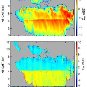
Clouds are a key element in the global hydrological cycle, and they have a significant role in the Earth’s energy budget through its influence on radiation budgets. Climate model simulations have demonstrated the importance of clouds in moderating and forcing the global energy budget. Despite the crucial role of clouds in climate and the breadth of our current knowledge, there are still many unanswered details. An improved understanding of the radiative impact of clouds on the climate system requires a comprehensive view of clouds that includes their physical dimensions, vertical and horizontal spatial distribution, detailed microphysical properties, and the dynamical processes producing them. However, the lack of fine-scale cloud data is apparent in current climate model simulations.
The Cloud Radar System (CRS) is a fully coherent, polarimeteric Doppler radar that is capable of detecting clouds and precipitation from the surface up to the aircraft altitude in the lower stratosphere. The radar is especially well suited for cirrus cloud studies because of its high sensitivity and fine spatial resolution.

