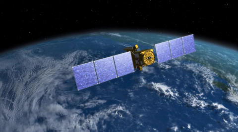
UMBC - A new study using data collected by NASA’s Plankton, Aerosol, Cloud, ocean Ecosystem (PACE) satellite established a novel method to determine how productive plants are worldwide. The new remote sensing technique could help us better understand plants’ role in capturing carbon on a global scale and reveal how plants are responding to factors like changing water availability and temperature, with relevance for conservation, agriculture, and more.
News
Leaf year: PACE satellite data reveals global plant health
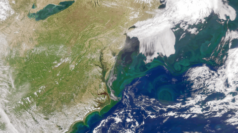
NASA Satellites Track Plankton Swarms from Space to Protect North Atlantic Right Whales
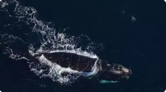
Times of India - The North Atlantic Right Whale (NARW), one of the most critically endangered mammals on Earth, continues to be threatened with several dangers despite the prohibition of commercial whaling. Entanglement in fishing nets and collisions with ships are now the greatest dangers to their existence. To help protect these whales from these dangers, scientists have come up with creative ways of monitoring their habits and reducing these dangers.
AGU 2024: NASA Science on Display in Nation's Capital
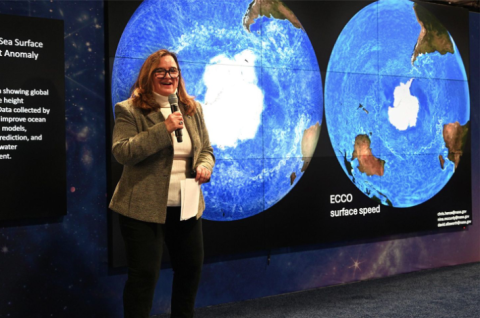
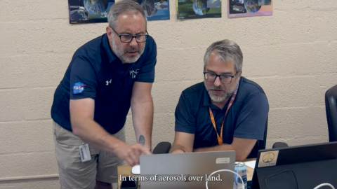
NASA Explore - The American Geophysical Union (AGU) returned to the nation’s capital in 2024, hosting its annual meeting at the Walter E. Washington Convention Center in Washington, DC from December 9–14, 2024. NASA Science upheld its long-standing tradition as an AGU partner and exhibitor, leveraging the meeting as an opportunity to share NASA’s cutting-edge research, data, and technology with the largest collection of Earth and planetary science professionals in the world. Many of the estimated 25,000 students, scientists, and industry personnel who attended the conference visited the NASA Science exhibit, interacting with NASA subject matter experts as detailed in the essay that follows – see Photo 1. Visitors also watched live Hyperwall presentations and collected NASA Science outreach materials, such as the 2025 NASA Science Planning Guide.
Dutch Space Instrument SPEXone Produces World Map of Aerosols
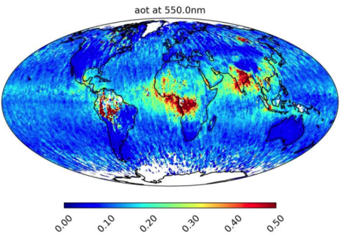
SRON Netherlands Institute for Space Research- On February 8, 2024, NASA launched its PACE climate satellite with the Dutch aerosol instrument SPEXone onboard. A full year of observations now yields a world map of aerosols.
It shows the distribution of fine and coarse aerosols and of particles that reflect or absorb sunlight. The latter respectively have cooling and warming effects on the climate. SPEXone was built by SRON and Airbus Netherlands, with support from TNO.
How a New NASA Satellite Could Help Solve the Global Temperature Spike Mystery

ABC News - Last year, 2024, was the warmest year on record for the planet, easily breaking the previous record set just a year earlier.
Scientists say the unfolding El Niño event superimposed on long-term global warming is a primary driver of this huge spike in global surface temperatures since mid-2023. But the magnitude of the increase shocked many experts, leaving them somewhat puzzled about what else could be behind the remarkable rise.
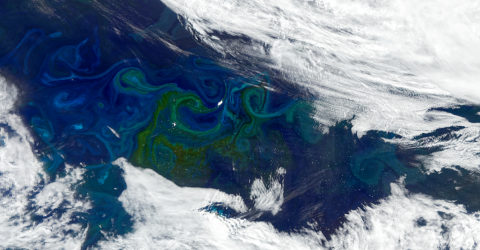
NASA Confirms It - This is the True Color of the Oceans

Union Rayo - No calm sea ever made a skilled sailor, or so they say. Now that we’re talking about the sea… could you tell what colour the sea is? Does it depend on where you are? Or is it always blue? Green? Light blue? We know that none of us really know what colour the sea is, we know that it has light blue and light blue tones, and that if it rains it turns green, but… what if we saw the oceans of our planet from space for the first time, just as they look from up there?
Well, it has been possible thanks to the PACE satellite (Plankton, Aerosol, Cloud, Ocean Ecosystem), a satellite created by NASA that works as an inverse telescope, that is, it constantly records the Earth to see how it looks from up there.
Discover the Help Hub for Ocean Color Learning Resources
NASA - EarthData Are you looking for data learning resources to work with NASA's ocean color datasets, services, and tools? The new Help Hub, released by NASA's Ocean Biology Distributed Active Archive Center (OB.DAAC), provides access to many helpful ocean color resources including:
- Tutorials and webinars that teach users how to access and process ocean color data in a Python Jupyter Notebook environment
- OB.DAAC’s official analysis and visualization of remote sensing data software, and much more
NASA Unveils the Stunning Turquoise Phenomenon Transforming Patagonia's Oceans

Scitechdaily - Blossoming Seas: The Marvel of Phytoplankton
Bloom season has been underway for several months, showcasing vibrant activity in the nutrient-rich South Atlantic waters off Argentina. During austral spring 2024, satellites captured a striking image of a large phytoplankton bloom along the Patagonian Shelf. These tiny aquatic organisms thrived through the extended daylight of the Southern Hemisphere summer, coloring the ocean’s surface in vivid shades of green and blue into late December.
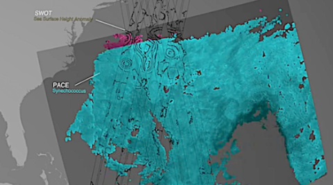
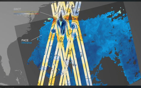
Unlocking Ocean Secrets: NASA’s PACE and SWOT Reveal a Hidden World
JPL - One Earth satellite can see plankton that photosynthesize. The other measures water surface height. Together, their data reveals how sea life and the ocean are intertwined.
NASA’s SWOT and PACE missions offer unprecedented insights into the ocean’s role as a climate engine and life-supporting system. By combining SWOT’s physical measurements with PACE’s biological observations, scientists can better understand how ocean dynamics impact marine ecosystems, fisheries, and carbon cycling.
Phytoplankton Flourish in Patagonian Waters
NASA earth observatory - Bloom season, already underway for several months, continued to dazzle in the productive South Atlantic waters off Argentina. Earlier, in austral spring 2024, satellites captured a clear image of a sizeable phytoplankton bloom along the Patagonian Shelf. Communities of the tiny aquatic organisms persisted into the long days of the Southern Hemisphere summer, painting surface waters in shades of green and blue into late December.
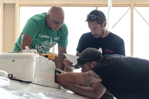
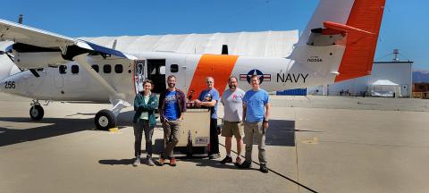
PACE-PAX Scientists Take to the Sea and Air (and Really High Air)
NASA Goddard - One of NASA’s most expansive and complex field campaigns took place over the month of September. The goal: to check the data that the new PACE satellite is collecting from orbit about Earth’s atmosphere and ocean. To do that, NASA’s PACE-PAX (Plankton, Aerosol, Cloud, ocean Ecosystem mission Postlaunch Airborne eXperiment) deployed several aircraft and ships from multiple locations in California, including Marina, Santa Barbara, and NASA's Armstrong Flight Research Center in Edwards.
PACE-PAX: A Day in the Life of a NASA Field Campaign

NASA - The breeze across the California desert kicks up some dust and sand. As a NASA research plane rolls down the runway and prepares for takeoff, its wings vibrate with the gust of wind. It’s a flight day for one of NASA’s most expansive and complex field campaigns.
The goal: to check the data collected from orbit by NASA’s PACE (Plankton, Aerosol, Cloud, ocean Ecosystem) mission. To do that, members of the PACE-PAX (PACE Postlaunch Airborne eXperiment) field campaign deployed two aircraft and a research ship from multiple locations in California over the duration of September 2024.
NASA’s PACE, US-European SWOT satellites offer combined look at Ocean
satnews - “We see great opportunity to dramatically accelerate our scientific understanding of our oceans and the significant role they play in our Earth system,” said Karen St. Germain, director of the Earth Science Division at NASA Headquarters in Washington. “This visualization illustrates the potential we have when we begin to integrate measurements from our separate SWOT and PACE ocean missions. Each of those missions is significant on its own. But bringing their data together — the physics from SWOT and the biology from PACE — gives us an even better view of what’s happening in our oceans, how they are changing, and why.”
NASA’s PACE, US-European SWOT Satellites Offer Combined Look at Ocean
JPL - The ocean is an engine that drives Earth’s weather patterns and climate and sustains a substantial portion of life on the planet. A new animation based on data from two recently launched missions — NASA’s Plankton, Aerosol, Cloud, ocean Ecosystem (PACE) and the international Surface Water and Ocean Topography (SWOT) satellites — gives a peek into the heart of that engine.
High Altitude ER-2 Flights Get Down-to-Earth Data
AEROTECHNEWS - Operating at altitudes above 99 percent of the Earth’s atmosphere, NASA’s ER-2 aircraft is the agency’s highest-flying airborne science platform.
With its unique ability to observe from as high as 65,000 feet, the ER-2 aircraft is often a platform for Earth science that facilitates new and crucial information about our planet, especially when the plane is part of collaborative and multidisciplinary projects.
Scientists Baffled by 2024's Unprecented Heat

SciTechDaily - In a groundbreaking development, 2024 recorded the hottest June through August on record, continuing a staggering streak of record-breaking global temperatures that began in June 2023.
This unexpected surge in temperature, described by climate scientists as both humbling and confounding, has prompted an intense investigation into the contributing factors.
Mapping Ocean Ecosystems with NASA Technology at PACE Hackweek

University of RI - GSO At NASA’s PACE Hackweek, Sarah Lang, a Ph.D. candidate at GSO, worked on a multi-institutional team to explore how mesoscale eddies—swirling ocean currents spanning 10-100 km—affect phytoplankton ecosystems, which are vital to the overall health of oceanic ecosystems and future climate
The Earth Observer Editor’s Corner: Fall 2024
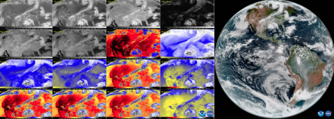
NASA Science - On September 18, 2024, the National Oceanic and Atmospheric Administration (NOAA) shared the first images of the Western Hemisphere from the GOES-19 satellite, its newest geostationary satellite launched on June 25, 2024 onboard a Falcon Heavy rocket from NASA’s Kennedy Space Center. Previously known as GOES-U, the satellite was renamed GOES-19 upon reaching geostationary orbit on July 7, 2024. GOES-19 orbits about 35,785 km (~22,000 mi) above the equator at the same speed the Earth rotates, allowing the satellite to constantly view the same area of the planet and track weather conditions and hazards as they happen. The satellite’s Advanced Baseline Imager (ABI) instrument recently captured stunning views of Earth in 16 spectral channels. This data provides researchers information about Earth’s atmosphere, land, and ocean for short-term forecasts and tracking severe weather – see Figure. ABI data is also used for detecting and monitoring environmental hazards, such as wildfires, smoke, dust storms, volcanic eruptions, turbulence, and fog. Data from multiple ABI channels can be combined to create imagery that approximates what the human eye would see from space referred to as GeoColor
Updates on NASA Field Campaigns
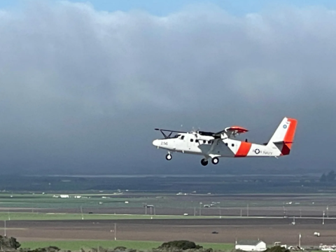
NASA Science - The primary objective of the Plankton, Aerosol, Cloud, ocean Ecosystem–Postlaunch Airborne eXperiment (PACE–PAX) is to gather data to validate measurements from NASA’s PACE mission. A secondary objective was validation of observations by the European Space Agency’s recently launched Earth Cloud, Aerosol, and Radiation Explorer (EarthCARE) mission. The operations spanned Southern and Central California and nearby coastal regions, logging 81 flight hours for the NASA ER-2, which operated out of NASA’s Armstrong Flight Research Center (AFRC) in Edwards, CA, and 60 hours for the Twin Otter aircraft, which was operated by the Center for Interdisciplinary Remotely Piloted Aircraft Studies (CIRPAS) at the Naval Postgraduate School (Monterey, CA) out of Marina Municipal Airport in Marina, CA
Validating PACE and Inspiring Future Scientists

EarthObservatory - This story is from one of 63 virtual student engagement events held for NASA’s Plankton, Aerosol, Cloud, ocean Ecosystem Postlaunch Airborne Experiment (PACE-PAX). The mission used aircraft (the NASA ER-2 and CIRPAS Twin Otter) and waterborne research vessels (R/V Blissfully,R/V Shearwater, and R/V Fish) to calibrate and validate the data from the PACE satellite, which was launched in February 2024. California was the main hub for the mission, with most of the airborne and waterborne activities occurring in Edwards, Marina, Long Beach, and Santa Barbara.
NASA'S High-altitude ER-2 Flights Use High-tech Sensors for PACE-PAX Project

Military Aerospace Electronics - Operating at altitudes above 99% of the Earth’s atmosphere, NASA’s ER-2 aircraft is the agency’s highest-flying airborne science platform. With its unique ability to observe from as high as 65,000 feet, the ER-2 aircraft is often a platform for Earth science that facilitates new and crucial information about our planet, especially when the plane is part of collaborative and multidisciplinary projects, Erica Heim writes for NASA. Continue reading original article.
Introduction to the PACE Mission for Water Quality Monitoring
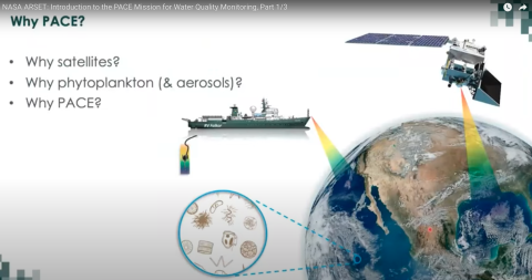
NASA Video - Introduction to Plankton, Aerosol, Cloud, Ocean Econtroduction to Plankton, Aerosol, Cloud, Ocean Ecosystem (PACE) Hyperspectral Observations for Water Quality Monitoring Part 1: Introduction to the PACE Mission for Water Quality Monitoring ARSET Trainers: Amita Mehta Guest Instructors: Antonio Mannino Learning Objectives: 1. Review past and current hyperspectral missions useful for water quality applications 2. Identify key features of the NASA PACE hyperspectral mission satellite and instruments useful for monitoring water quality of large lakes and estuaries 3. Identify advantages and limitations of using PACE/OCI data for water quality monitoring
Twenty-one Hours a Day on a 30-Foot Floating Science Lab

Research Vessel (RV) Blissfully is a 30-foot sailboat that is the science lab and home for two sailing scientists, Captain Gordon Ackland and myself, Dr. Bridget Seegers. The RV Blissfully is a recent addition to the fleet of research vessels. Previously, Blissfully’s days were primarily spent peacefully floating snug in a San Diego boat slip with an occasional day sail. However, Blissfully was volunteered to support the PACE-PAX campaign and therefore transitioned a month ago into RV Blissfully.
Orbital Biosignature Survey: Lake Erie Algal Bloom
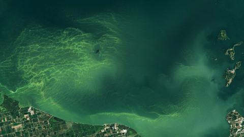
Astrobiology - Algal blooms have become a common occurrence on Lake Erie, as much a part of summer at the lake as island-hopping, scenic cruises, and roller coasters. In 2024, a bloom of blue-green algae began forming in the lake’s western basin on June 24—the earliest that a bloom has been identified by NOAA since the agency began tracking them in 2002. It was still present in early September. Bloom season can last into October, with its duration depending on the frequency of wind events that mix lake waters in the fall.
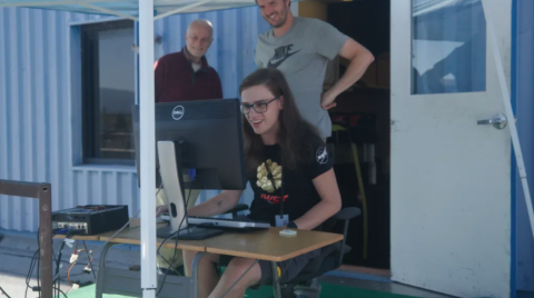
Day-in-the-Life of a PACE-PAX Mission Flight

06:00 Local Time: Go/No-Go Meeting We are in the field supporting PACE-PAX (Plankton, Aerosol, Cloud, ocean Ecosystem Postlaunch Airborne eXperiment), a multi-disciplinary mission that involves two aircraft—the NASA ER-2 and CIRPAS Twin Otter—and several mobile ocean assets, all helping to validate observations and data products from NASA’s new satellite observation platform, PACE. Our days typically start with an initial look at the weather in the area of operations and airport conditions during takeoff and landing. Both the ER-2 and Twin Otter will fly today since the weather is acceptable for launch, science, and landing.
Sailing Away for PACE

Hello from sunny Santa Barbara, California, where the ship operations for the PACE-PAX campaign are underway!
The PACE satellite went into orbit in February 2024. Its mission is to help us better understand how the ocean and atmosphere exchange carbon dioxide, as well as how aerosols can fuel phytoplankton blooms and help us track harmful algal blooms around the planet.
PACE-PAX stands for Plankton, Aerosol, Cloud, ocean Ecosystem – Postlaunch Airborne eXperiment (see why we made it shorter?) We are using two airplanes and three ships, among other free-sailing instruments, to gather data that will tell us how well our shiny new satellite, PACE, is doing. We compare our planet-side data with the space-side data so we can make sure we are providing the very best information about the health of the world’s oceans.
NASA Earth Scientists Take Flight, Set Sail to Verify PACE Satellite Data
NASA - More than 100 scientists will participate in a field campaign involving a research vessel and two aircraft this month to verify the accuracy of data collected by NASA’s new PACE satellite: the Plankton, Aerosol, Cloud, ocean Ecosystem mission.
Stephen Broccardo: A ‘STAR’ in PACE Data Collection
NASA Blogs - Stephen Broccardo, research scientist at NASA’s Ames Research Center in California’s Silicon Valley, is the principal investigator for the Sea-going Sky-Scanning Sun-tracking Atmospheric Research Radiometer (SeaSTAR). The ship-based instrument is one of many in a campaign set out to gather data around the world to check the information that NASA’s PACE (Plankton, Aerosol, Cloud, ocean Ecosystem) satellite is collecting in orbit. Broccardo will use SeaSTAR for the first time in an upcoming PACE validation campaign.
Shifting Sea Ice is Making Sailing Ships Through the Northwest Passage More Difficult
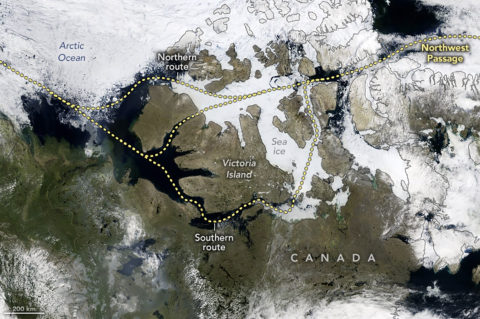
GEOGRAPHY REALM - The Northwest Passage connects ship traffic through the Arctic Ocean to connect the Atlantic Ocean with the Pacific Ocean. The passage winds through a cluster of islands north of mainland Canada, offering a potentially shorter route between oceans but posing significant challenges due to the unpredictable Arctic waters and shifting ice.
Arctic Ice Won't Let Go: The Surprising Truth Behind the Northwest Passage
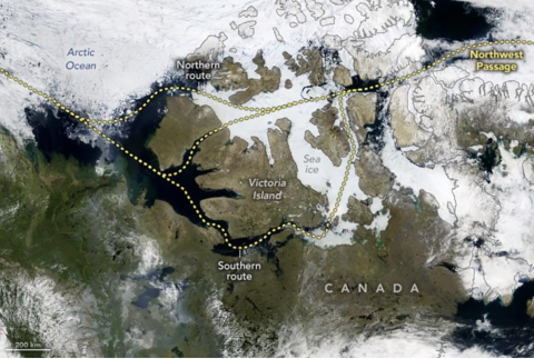
SciTechDaily - On July 13, 2024, the OCI (Ocean Color Instrument) aboard NASA’s PACE (Plankton, Aerosol, Cloud, ocean Ecosystem) satellite captured a rare, mostly cloud-free image of the islands and waterways that form the crux of the Northwest Passage.