La Administración Nacional de Aeronáutica y del Espacio (NASA) utilizó un avión espía para inspeccionar y mejorar los pronósticos de nieve. Se trató del N809NA que despegó la mañana del miércoles 19 de enero del aeródromo Pope Army en Fayetteville, Carolina del Norte.
News
Así es como un avión de la NASA busca advertir las tormentas en Carolina del Norte

Did you see it? NASA uses retired spy plane to survey, improve snow forecasts

If you looked up early Wednesday afternoon and noticed an unusual looking white aircraft high up against the clear Carolina blue skies, you caught a rare glimpse of a spy plane-turned science platform for NASA.
Snow is difficult to measure, but technology is providing new ways to determine how much snow is falling from the sky
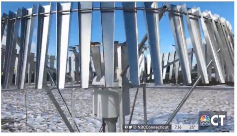
With snow expected this week, you probably have a shovel handy and are keeping an eye on road conditions, but scientists see snow days as an opportunity to learn a lot and even predict future weather events.
Team From NASA Flies Into the Heart of Winter Storm

There hasn’t been much snow this year but that’s not stopping a team from NASA from flying into the heart of a winter storm. NBC10’s Tim Furlong joined them for the ride.
Scientists Chase Snowflakes During the Warmest Winter Ever

INSIDE A CAVERNOUS hangar at NASA’s Wallops Flight Facility along the Virginia coast, a gleaming white P-3 Orion aircraft sits parked under harsh floodlights. It’s just after midnight and a group of scientists, technicians and graduate students cluster underneath a wing, peering at a 5-inch crack in one of the ailerons that the pilot uses to maneuver the plane.
Their disappointment is palpable. The eight-person team was preparing to board the research aircraft for a 10-hour flight through a massive snowstorm stretching across upstate New York and Canada as part of a new project funded by NASA to dissect the inner workings of winter storms. The researchers want to know how the bands of snow form, why some storms produce snow and others don’t, and why certain conditions lead to ice crystals, while others cause snowflakes. Their ultimate goal is better winter forecasts for the 55 million residents of the Northeast, and improved weather models that can be used for the rest of the US. NASA has dubbed the three-year study IMPACTS, or the Investigation of Microphysics and Precipitation for Atlantic Coast-Threatening Snowstorms.
NASA Launches In-Depth Snow Study—First in 30 Years
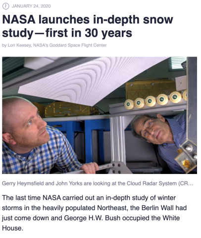
The last time NASA carried out an in-depth study of winter storms in the heavily populated Northeast, the Berlin Wall had just come down and George H.W. Bush occupied the White House. That changed in mid-January when a team led by University of Washington researcher Lynn McMurdie began a six-week campaign to better understand how snow bands form and evolve.
Winter Storm Research Gets a Local Helping Hand

Winter snow in the Northeast is quickly catching up with death and taxes in terms of guarantees. We may catch a lucky break every now and then (see: current winter) but more often than not, we get quite powdery from December to March - sometimes in November and April too! While much of the country turns white during the winter, we along the eastern seaboard are more susceptible to really big snows thanks to our ocean proximity. Land-originating systems like Alberta Clippers typically move through rapidly, and thus leave us with minor accumulations. Cold fronts can sometimes cause headaches, but warmer air riding up ahead of them is also a limiting factor (that rain/snow line loves to play games with us forecasters.) But coastal storms (often Nor'easters) pack an extra punch. They usually contain a lot more moisture, and when they interact with arctic air coming down from Canada, you can get a winter wonderland in a hurry.
New NASA 'Snow Chaser' Plane Prepares for Takeoff to Improve Weather Forecasts

WALLOPS ISLAND, Va. – It is pretty to look at, but at times, treacherous to encounter: when snowstorms wreak havoc on the ground, it can come with a cost. Yet, because of limited research, snowstorms are not as well-understood as other weather phenomenon. That’s about to change. Inside a noisy hangar at NASA’s Wallops Island facility in Virginia sits a specially outfitted P-3 aircraft, also known as a “snow chaser.” “Snow can have a huge economic impact,” said Lynn McMurdie, principal investigator for a new research project called IMPACTS. “To be able to fly inside the clouds, where the snowflakes form, enables us to study the processes that go into forming the snowflakes that eventually fall down to the earth as snowfall in your backyard.”
NASA Snow-Chasers Fixed to Travel Into Winter Storms to Inquire The Inner Workings

With snow undermining access to streets, work, and school, snowfall is one of the essential winter climate marvels on the U.S. East Coast. It’s likewise one of the hardest to anticipate.This month NASA is sending a group of researchers, a large group of ground instruments, and two research airplanes to consider the internal activities of blizzards. The Investigation of Microphysics Precipitation for Atlantic Coast-Threatening Snowstorms, or IMPACTS, has its first arrangement in a multi-year field crusade from January 17, 2020, through March 1, 2020. It will be the exhaustive primary investigation of East Coast blizzards in 30 years.
NASA Taps Snowstorm-Chasing Team To Improve Forecasting

NPR's Ailsa Chang speaks with Lynn McMurdie, a University of Washington professor and principal investigator for IMPACTS, NASA's new project to more accurately predict snowstorms.
NASA Wallops to Help in Study to More Accurately Predict Snow Storms

This month NASA is sending a team of scientists, a host of ground instruments, and two research aircraft to study the inner workings of snowstorms. The Investigation of Microphysics Precipitation for Atlantic Coast-Threatening Snowstorms, or IMPACTS, has its first deployment in a multi-year field campaign from Jan. 17 through March 1. It will be the first comprehensive study of East Coast snowstorms in 30 years.
NASA Snowstorm Study Will Send Planes Inside of East Coast Storms

For many of us, a few inches of snow can be a nuisance, or at the very least keep us from getting to work on time. The worst part about impending snowstorms, however, is when we have no idea how much snow we're going to get during a given snowfall event. Meteorologists often give us an estimation of what we're up against with the fluffy precipitation, but the work that goes into bringing viewers an idea of whether they should call in to work or get out the shovel is hard, frustrating stuff. Many snowstorms actually can't be observed closer than what modern instruments already allow, thanks to parts of storm clouds that scientists just don't know much about. Luckily, NASA is putting together a snowstorm study meant to help improve these types of forecasts by, well, learning more about said clouds. NASA's latest venture is called the Investigation of Microphysics and Precipitation for Atlantic Coast-Threatening Snowstorms, or IMPACTS. The team is looking to understand how "ribbons" of snow clouds, otherwise known as snow bands, form and change as they bring snowfall to areas on the East Coast. The idea is to get an understanding of how they form right down to the ice crystals inside.
NASA Near-Space Airplane Touches Down in Savannah

A high-flying NASA research plane arrived Wednesday at Hunter Army Airfield to begin a two-month mission of collecting data on East Coast snowstorms. One of NASA’s two Lockheed ER-2 flying laboratories — capable of reaching altitudes of over 68,000 feet — was flown from its base in Palmdale, California to Savannah, touching down at sunset. The advanced aircraft, similar to the Lockheed U-2 spy plane, will be stationed at Hunter through the rest of winter to carry out research for the space agency’s three-year Investigation of Microphysics and Precipitation for Atlantic Coast-Threatening Snowstorms (IMPACTS).
NASA ‘Snow Hunters’ to Fly into East Coast Storms to Improve Forecasts

Traffic-snarling, routine-ruining snowstorms are a fact of life in the eastern United States, but the region’s snowfall forecasts are notoriously difficult to make. This is partly because scientists don’t know much about what’s going on inside certain narrow ribbons of turbulent storm clouds, called “snow bands,” that can contain some of a storm’s heaviest snowfall rates. Such areas of heavy precipitation can easily turn a carefully made snowfall forecast into a bust and unexpectedly paralyze highly populated regions, depending on their location and movement. Now, NASA is gearing up to study East Coast snowstorms for the first time in 30 years. The agency’s latest airborne campaign, known as the Investigation of Microphysics and Precipitation for Atlantic Coast-Threatening Snowstorms, or IMPACTS, seeks to understand how small-scale snow bands form and evolve, and what’s happening inside them down to the level of individual ice crystals.
NASA Sets Up Camp at Hunter Army Airfield to Study East Coast Snowstorms

SAVANNAH, Ga. (WTGS) — On Tuesday, NASA sent a high-flying plane with a 150 ft wingspan to measure snowstorm activity to the Hunter Army Airfield. NASA's ER-2 arrives at 5 p.m. It will measure the distribution of raindrops, snowflakes, and ice particles vertically in the cloud, as well as how they move. “All this information is important and complementary,” said IMPACTS’ deputy principal investigator John Yorks of NASA Goddard. “The data collected directly in the cloud by the P-3 will inform how we interpret the remote sensing data from the ER-2 and help us understand the structure and evolution of the snow bands.”
NASA snow chasers begin mission at Hunter Army Airfield
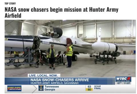
SAVANNAH, Ga. (WTOC) - NASA scientists will begin their data collection mission into east coast winter storms in Savannah.They’re doing this to better predict winter storms before they happen and give the public a better understanding of how they happen.“Trying to understand what is in the atmosphere and of that day that caused these horrific events,” said Tim Williams, Research Test Pilot for Armstrong Flight Research Center with NASA.Williams says this mission has been in the works for about two years. The first part of the $30 million mission begins this Friday and will end March 1.And In order to do all of this, they’ll be flying in two different planes. NASA’s P-3 Orion and ER-2.
NASA Unveils New Technology to Examine Snow Storms

WALLOPS ISLAND, Va.- For the first time in 30 years, NASA is revamping how it looks at snow storms. On Tuesday, the agency unveiled its IMPACTS mission--a snowstorm chasing field campaign along the East Coast. NASA will be using two specialized aircraft to investigate each storm: the ER-2 high-altitude aircraft and the NASA P-3 aircraft. The latter will be housed at Wallops Island. "Studying east coast snowstorms is a big forecasting challenge so that was the challenge that was put forth in front of us," says Dr. Lynn McMurdie, a University of Washington research Associate Professor. "Another thing that's challenging is forecasting the distribution of snow, where is it going to snow heavily, where is it going to not snow as heavily. In each individual storm it varies from storm to storm."
NASA Wallops Studying East Coast Snowfall Using Airplanes

WALLOPS ISLAND, Va. – NASA scientists are about to embark on a new journey, flying a plane right into the center of a storm to better understand snowfall on the East Coast. “NASA has not done, actually scientists have not done, experiments looking at the details of those storms for 30 years,” says Gail Skofronick-Jackson, a program scientists for NASA’s IMPACTS Mission. Scientists are sharing details about NASA’s new field campaign “Investigation of Microphysics and Precipitation for Atlantic Coast-Threatening Snowstorms”, also known as IMPACTS. Experts say there’s already a lot of data on rain but not enough on winter weather. So they’re using planes to gain some more insight.
NASA Snow-Chasers Set to Fly Into East Coast Winter Storms

This month NASA is sending a team of scientists, a host of ground instruments, and two research aircraft to study the inner workings of snowstorms. The Investigation of Microphysics Precipitation for Atlantic Coast-Threatening Snowstorms, or IMPACTS, has its first deployment in a multi-year field campaign from Jan. 17 through March 1. It will be the first comprehensive study of East Coast snowstorms in 30 years.
Media Invited to Preview of New NASA Field Campaigns

NASA is inviting members of the media to a behind-the-scenes tour and briefing on five new research campaigns that will take to the field in 2020 to explore questions critical to understanding our home planet. The event is scheduled for Tuesday, Jan. 7, from 7 a.m. to 12:30 p.m. PST at NASA’s Armstrong Flight Research Center, Building 703, in Palmdale, California.
NASA to Study East Coast Snowstorms from VA. Skies

NASA has announced it will use Wallops Island Flight Facility, just south of Chincoteague Island, as a jumping-off point to study Atlantic snowstorms starting in January.
It’s the first major field campaign to study East Coast snowstorms in 30 years.
The Investigation of Microphysics and Precipitation for Atlantic Coast-Threatening Snowstorms (IMPACTS) study will send a high-altitude aircraft (flying from Savannah, Georgia) and a cloud-sampling aircraft (flying from Wallops Island) to look closer at how snow is distributed in the clouds.
NASA explains that the “cloud processes” responsible for snowstorms are difficult to measure, and forecast models can’t reproduce them very well. That makes for poor snowfall predictions.
“People see pictures of these big swaths of clouds and think they’re snowing everywhere, but they’re not,” said IMPACTS principal investigator Lynn McMurdie at the University of Washington in Seattle. “Inside the clouds are these long narrow regions of more intense snow bands. We’re trying to understand why they form and how they evolve with the developing storm.”
Since the last time East Coast snowstorms were studied from the air, instruments have become much more advanced. NASA says now is “an ideal time to conduct a well-equipped study to identify key processes and improve remote sensing and forecasting of snowfall.”
NASA’s ER-2 and P-3 aircraft will fly for three six-week deployments.
-Meg Walburn Viviano
NASA embarks on five US expeditions targeting air, land and sea
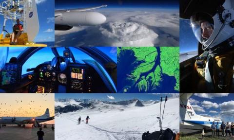
NASA is sending five airborne campaigns across the United States in 2020 to investigate fundamental processes that ultimately impact human lives and the environment, from snowstorms along the East Coast to ocean eddies off the coast of San Francisco.
NASA Embarks on Five U.S. Expeditions Targeting Air, Land and Sea

NASA is sending five airborne campaigns across the United States in 2020 to investigate fundamental processes that ultimately impact human lives and the environment, from snowstorms along the East Coast to ocean eddies off the coast of San Francisco.
Disclaimer: This material is being kept online for historical purposes. Though accurate at the time of publication, it is no longer being updated. The page may contain broken links or outdated information, and parts may not function in current web browsers. Visit https://espo.nasa.gov for information about our current projects.