This site requires that JavaScripts be enabled in your browser. For instructions,
click here
Skip to main content
NASA - National Aeronautics and Space Administration
You must have JavaScript enabled to use this form.
›
Log in to Operation IceBridge
|
›
Create New Account
Log in to Operation IceBridge
Username
*
Password
*
Create new account
Request new password
Search form
Search
Leave this field blank
ESPO
Missions
About ESPO
Video about ESPO
Services
Deployment Sites
Aircraft
Satellites
Links
ESPO Archive
Browse
Help
Flight Request
Mission Tools
ASP Mission Tool Suite
OIB Home
OIB HQ
Mission Planning
Mission Calendar
Daily Schedule
Logistics
Deployment Sites Information
Punta Arenas, Chile
Ushuaia, Argentina
Thule, Greenland
Kangerlussuaq, Greenland
Shipping
Wallops Island, VA
Palmdale, CA
Punta Arenas, Chile
Ushuaia, Argentina
Lodging & Car Rental
Palmdale, CA
Punta Arenas, Chile
Ushuaia
Integration Sites
Forms
Science
Flight Overview
Arctic
Alaska
Antarctica
Presentations
Platforms
Airborne
DC-8
G-V
P-3
UAF Otter
Satellites
Participants
Links
Photos
Fall 2016
Fall 2015
Fall 2014
Fall 2012
Thule Operations #1 in 2012 Spring
Thule Operations #2 in 2012 Spring
Kangerlussuaq Operations in 2012 Spring
Fall 2011
Fall 2010
Spring 2010
Fall 2009
Spring 2009
Videos
OIB Blog
Twitter @NASA_ICE
Operation IceBridge
Home
>
OIB - Gallery
> OIB - Gallery
People
Mike Singer P-3 (Pilot in Command)Morning flight planning
Data
Figure 2
Figure 7
FIgure 2
Figure 2
Figure 1
A canyon in shadow, Antarctic Peninsula
Dirty blue ice, Antarctic Peninsula
ATM T6 mapping of a crevasse field
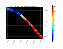
Elevation along the eastern portion of the pole hole
FLIR brightness temperature over South Pole, offset from DMS image, pointing out building heat signatures
Nadir view of South Pole Station from 20,000’ AGL
MCoRDS data collection showing significant subglacial relief associated with Dyer Plateau pyramidal nunataks
ATM T6 swath map of crevassing
Pack drift from ATM
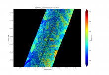
Echogram of Renland Ice Cap
Figure 2: Flight deck of the USS Constellation anchored in Punta Arenas. Credit: Digital Mapping System/NASA.
Figure 1: Today's trajectory in yellow and mission plan in red.
Infrared satellite image available before takeoff
DMS image of one of the start/end of the main survey grid.
Trajectory map of the 7 passes over the NRL ground site near Barrow.
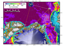
Today's mission plan and P-3 trajectory.
IR satellite image before takeoff
Today's mission plan and P-3 trajectory.
Today's mission plan and P-3 trajectory.
DMS image of Vostok Station
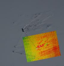
Data collection over ICESat-2 cal/val site in TAM
Today's mission plan and P-3 trajectory.
DMS mosaic of crevasses on MacAyeal Ice Stream (formerly Ice Stream E)
Today's mission plan and P-3 trajectory.
Pages
« first
‹ previous
…
2
3
4
5
6
7
8
9
10
…
next ›
last »