STAQS Sampling Summary

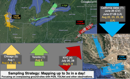
The colored blocks on the map represent of locations mapped by NASA aircraft during STAQS with noted flight dates. White circles show ground locations for measurements (PGN and TOLNet) supported by STAQS. Dates in yellow are those that coincide with TEMPO observations. 

Credits
Laura Judd
Subject
Mission


Disclaimer: This material is being kept online for historical purposes. Though accurate at the time of publication, it is no longer being updated. The page may contain broken links or outdated information, and parts may not function in current web browsers. Visit https://espo.nasa.gov for information about our current projects.