NASA: Fire Cloud With a Pileus on Top
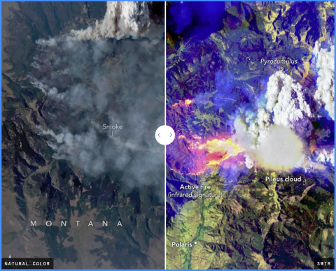
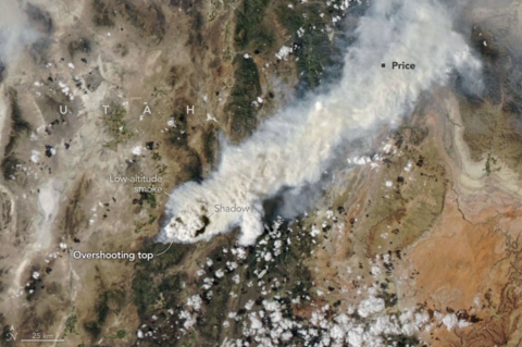
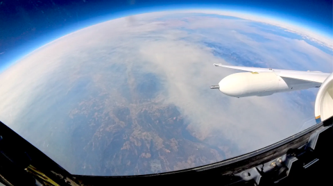
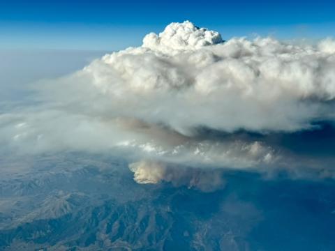
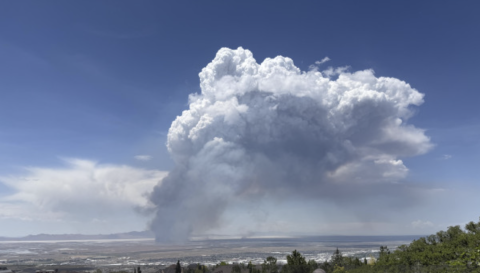
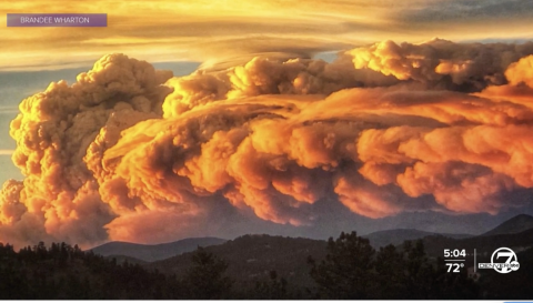
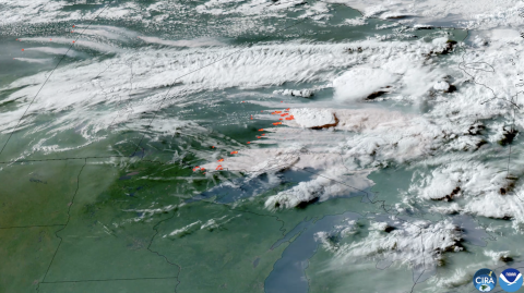
In summer 2026, scientists took to the air to intercept and study the towering, smoke-infused clouds that wildland fires sometimes create. But during an August 11 flight over the Sand Creek fire in Montana, they came back with a bonus—observations of an ephemeral pileus cloud hovering atop one of the towering fire clouds.
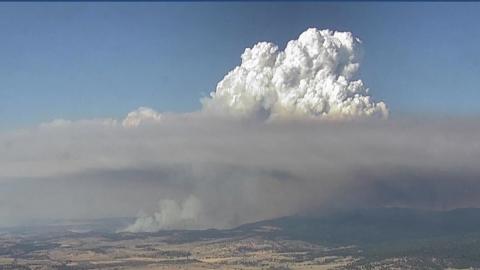
Smooth, veil-like pileus clouds are well-known to atmospheric scientists and cloud lovers and regarded as signs of especially vigorous convection. But researchers rarely observe a pileus cloud interacting with a fire cloud—known as a pyrocumulus (pyroCu)—in as much detail as they did on this flight, part of NASA’s INSPYRE (Injected Smoke and Pyrocumulonimbus Experiment) campaign.
PBS News: 'An unworldly experience.' Why scientists flew into firestorm clouds this wildfire season
As wildfires grow bigger and hotter in many parts of the world, researchers have embarked on an airborne mission to learn more about the severe storm clouds that sometimes form over the most intense blazes.
"Firestorm" clouds, or pyrocumulonimbus (pyroCb), can pump as much smoke into the stratosphere as a volcanic eruption. They are responsible for a range of extreme weather, from lightning to firenadoes, but much about their inner workings is unknown, which makes their behavior difficult to predict. That's a danger for the residents and emergency crews who might be in harm's way.
This summer, a team of scientists led by NASA, the U.S. Naval Research Laboratory (NRL) and the National Center for Atmospheric Research (NCAR) got an up-close look at these clouds by flying a pair of aircraft over and into wildfire smoke plumes with an array of measuring instruments.
"Being able to both sample inside the plumes and the clouds and above — and relating what we're seeing — that's something that we've never been able to do before," said John Yorks, a research physical scientist at NASA's Goddard Space Flight Center.
KTVZ21: NASA studies fire clouds during Oregon’s record 2.5 million-acre burn season
BEND, Ore. (KTVZ) -- Oregon's 2026 wildfire season set a state record with nearly 2.5 million acres burned, surpassing the previous record of approximately 2 million acres. During the historic season, NASA researchers deployed to Central Oregon as part of the INSPYRE mission to study fire-generated clouds.
The severe fire season prompted crews nationwide and internationally to assist in Central Oregon, where several blazes became top national priorities, including the Akawa Butte Fire. Alongside emergency crews, NASA scientists gathered data on pyro-cumulus clouds—large thunderstorm systems created by intense heat and smoke rising from active wildfires.
David Peterson serves as the lead principal investigator for the INSPYRE mission at NASA. Peterson emphasized that fire-generated clouds remain a relatively new subject for scientific research. “These fire generated clouds are relatively new area of study. And they're still not that well understood, other than they seem to form over large and intense wildfires. But we really don't know the dynamics of that fire. You know, how much of an area is burning at the time? How hot is the fire? And at the same time, what is the atmosphere condition above that fire and how is that helping to generate the thunderstorm environment,” Peterson said.
El Economista: Los incendios crean sus propias tormentas y la NASA estudia sus nubes para predecir cómo evolucionarán los fuegos
Estudiar las nubes generadas por los grandes incendios ayuda a predecir su evolución y a entender cómo el humo es capaz de alcanzar las capas altas de la atmósfera, recorrer grandes distancias y afectar al clima y al ozono. En ello trabaja ahora la NASA. Hasta ahora se sabía que los volcanes pueden lanzar grandes cantidades de partículas a la estratosfera, pero se está estudiando cómo los incendios forestales también lo hacen, puesto que generan nubes pirocúmulonimbos (piroCb) cargadas de humo. Lo curioso de ellas es que generan enormes nubes de tormenta capaces de provocar rayos, granizo y fuertes lluvias. Es decir, los grandes incendios forestales son capaces de crear su propia meteorología.
Los pirocúmulos también pueden dejar una huella considerable en la atmósfera superior al canalizar pulsos de partículas y gases hacia la estratosfera, según numerosos estudios. De hecho, una vez que se sitúa allí, el humo puede extenderse ampliamente y persistir durante meses o años, a veces dando la vuelta al mundo y probablemente dando lugar a cambios en la capa de ozono y el clima de la Tierra. Esta es la razón por la que el humo de un incendio de Canadá consiguió llegar hasta nuestro país en 2023.
FOX13: NASA researchers study how wildfires create their own thunderstorms
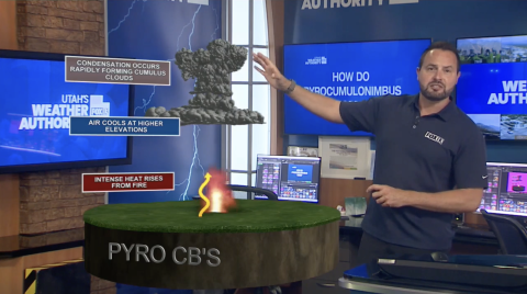
When a wildfire gets big and hot enough, it can actually create its own thunderstorm — a phenomenon called a pyrocumulonimbus, or pyroCb.
These fire-generated storms can dramatically intensify fire behavior while sending huge amounts of smoke high into the atmosphere.
Now, NASA and researchers from across the country are studying these extreme storms to better understand how they form, how they affect wildfires and what happens to the smoke once it reaches the upper atmosphere.
[From video transcript]
The Electric: NASA studying wildfire-generated storms with plane based out of Great Falls
David Peterson, a self-described weather nerd since he was a kid, is leading a multi-year national research project into wildfire-generated thunderstorms, with a component based out of Great Falls.
Peterson studied meteorology in college and when new satellites came online around 2005 that gave a good view if wildfires from space, he came across what’s known as pyrocumulonumbus storms, or pyroCBs.
He thought, “why not” study it and wanted to learn what drives pyroconvection, which leads to pyroCBs.
Weather data included in a study at the time didn’t make sense, piquing his interest in the idea that “fire can modify the atmosphere,” where conditions may not be favorable for thunderstorms, but fire and smoke could change atmospheric conditions.
It’s a pretty new area of study in meteorology, Peterson said, that’s having a moment a bit like the study of supercells did in the 1990s when the movie Twister was released.
International Business Times: NASA Captures Giant "Fire Clouds" Over Utah: What Are Pyrocumulonimbus Clouds?
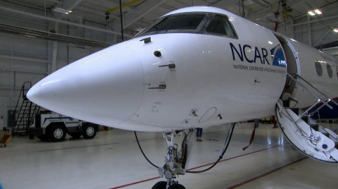
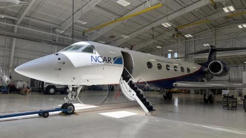
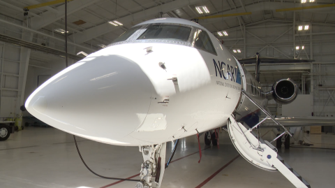
NASA scientists are studying towering pyrocumulonimbus, or pyroCb, clouds that formed above Utah's Widemouth 2 wildfire after the fire intensified in early August. On Aug. 3, 2026, an NSF/NCAR Gulfstream V aircraft flew through a high-altitude smoke plume from the fire over New Mexico, sampling smoke at roughly 12 kilometers (8 miles) above the ground.
The aircraft mission is part of NASA's INSPYRE (INjected Smoke and PYRocumulonimbus Experiment), which is investigating how wildfire-generated clouds can push smoke high into Earth's atmosphere. NASA Earth Observatory highlighted the Utah fire and the research on Aug. 17, 2026, as its Image of the Day.
The work matters because these clouds can do more than produce dangerous weather around a wildfire. The most powerful pyroCbs can send smoke and particles into the stratosphere, where they can spread over large areas and remain for months or even years.
Blue News: NASA is using a reconnaissance aircraft to study how wildfires generate storms
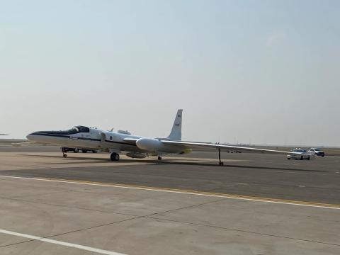
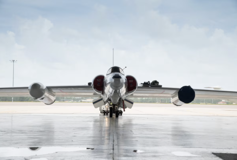
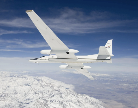
Wildfires can create their own weather—including thunderstorms, lightning, gale-force winds, and even fire tornadoes. To better understand these dangerous phenomena, the U.S. space agency NASA is using an unusual research aircraft: a modified Cold War-era U-2 spy plane.
The aircraft, now known as the ER-2, flies at an altitude of about 20 kilometers above active wildfires. Instead of cameras and military equipment, it carries state-of-the-art measuring instruments. As part of the research mission “INSPYRE” , NASA is studying so-called pyrocumulonimbus clouds, which are formed by the intense heat of wildfires.
"The smoke from the fire is forced upward as if through a chimney, accelerates within the vertical column, and is finally released," explains David A. Peterson of the Naval Research Laboratory to "CNN." The meteorologist is leading the mission. The fire is constantly providing new energy and can, in a sense, sustain itself.
DH News: Why a high-altitude NASA aircraft was recently flying over B.C. and the rise of firenadoes
A flight tracker recently uncovered that a NASA aircraft was flying in B.C. earlier this week, and we wanted to figure out why.
Dr. David Peterson is the principal investigator for the NASA INSPYRE project, and we had a one-on-one to discuss the B.C. portion of the mission.
Expanding that INSPYRE moniker gets us “INjected Smoke and PYRocumulonimbus Experiment,” and the reason the NASA aircraft was in B.C. was due to the prevalence of wildfires in the province and the ability for these wildfires to generate weather.
According to the NASA website, INSPYRE is testing the hypothesis that increasing wildfire size and intensity amplifies pyroCb-driven smoke into the stratosphere, which induces measurable changes to Earth’s “radiative balance.”
We learned from Peterson that B.C. is playing quite the role in this mission.
“It turns out that British Columbia, Canada, is actually one of the hotspots, if you will. Some of the largest fire-generated storm events ever recorded have occurred there.”
CNN: NASA’s ‘Dragon Lady’ is uncovering how wildfires create storms
Fire clouds, scientifically known as pyrocumulonimbus storms, are gigantic thunderstorms produced by wildfire heat. These storms can include lightning, strong winds, and in some cases, fire tornadoes.
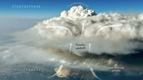
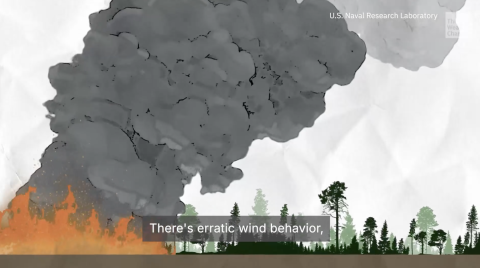
“It’s kind of like a chimney where the smoke from the fire is being pushed upward into the thunderstorm, accelerated through that vertical column, and then released,” said David A. Peterson, a meteorologist at the Naval Research Laboratory.
He is the principal investigator for NASA’s INjected Smoke and PYRocumulonimbus Experiment, or INSPYRE, a mission that will study these storms’ erratic behavior.
“The generated smoke column is basically a warm bubble that triggers the thunderstorm, so it’s like any other really tall, severe thunderstorm cloud, but now you’ve filled it with smoke. The fire at that point is essentially feeding itself,” Peterson said.
Meteorologists have not been able to properly forecast pyrocumulonimbus storms because they form during unpredictable conditions. Only recently, scientists discovered that these fire generated weather systems can surpass a natural atmospheric barrier, reaching the stratosphere.
Toronto Star: NASA aircraft flies high over B.C. wildfires to study pyrocumulonimbus clouds
CLINTON, BRITISH COLUMBIA, CANADA - A high-altitude research aircraft from NASA flew over British Columbia’s wildfires over the weekend in a bid to better understand weather events generated by large blazes.
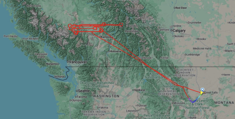
Online aviation tracking shows the ER-2 plane flew back and forth over B.C.‘s southern Interior more than a dozen times on Saturday on a flight of more than six hours that took off from Great Falls, Mont.
Data from the Flightradar24 website shows the plane spent about four hours at an altitude of 60,000 feet over the Clinton area, where the massive Pear Lake wildfire has been burning.
It also swung east over Lake Revelstoke before returning to U.S. airspace.
NASA says on its website that the ER-2 is researching pyrocumulonimbus clouds, which it describes as “one of the least understood forms of severe weather on Earth.”
The Weather Channel: Why scientists are flying into fire-breathing thunderstorms
Scientists from NASA’s INSPYRE mission are flying aircraft through the smoke of Western wildfires to study fire-generated thunderstorms that extreme blazes create. These thunderstorms are some of the most erratic and least understood storms on the planet. See why they are doing this and what it means to fighting fires in the future.
The Economist: NASA takes aim at fire storms
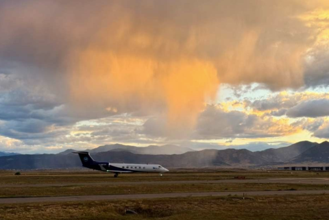
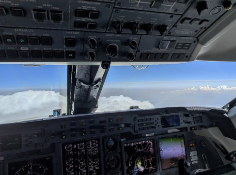
MOST AIRCRAFT try to avoid bad weather. Not so a Gulfstream V that taxied onto the runway of Rocky Mountain Metropolitan Airport, in Colorado, on July 29th. Its flight path was set to take it directly into a rare and little-understood weather event—a pyrocumulonimbus (pyroCb)—in Oregon. Such towering, smoke-tinged storm clouds form above wildfires and generate weather that can multiply the damage of the fires that cause them.
Yahoo!News: Meet the scientists who are flying into fire-breathing thunderstorms, and learn why they are doing it
When a wildfire burns hot enough, it starts making its own weather. And right now, no one can reliably predict when and where that's going to happen. This can not only be extremely dangerous for firefighters on the ground, but it can also spark new fires nearby.
This is one of the least understood types of weather in the world, and that's why NASA has gathered a team of scientists to study the storms that wildfires produce.
This NASA-funded mission is called INSPYRE, the INjected Smoke and PYRocumulonimbus Experiment. They are studying pyrocumulonimbus (pyroCb), which are thunderstorms born from the heat of a fire.
Fox Weather: NASA and Navy study wildfire-generated 'fire clouds'
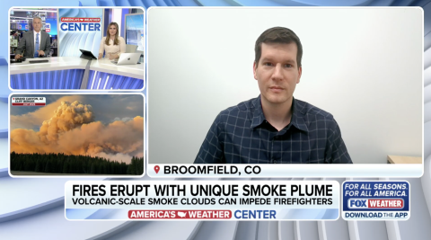
Reporter 1: NASA and the Naval Research Laboratory are trying to understand more about the atmospheric impacts of these volcanic-scale plumes of smoke. I mean, they are pretty big.
Reporter 2: Yeah, Dr. David A. Peterson joins us now. He's a Naval Research Lab meteorologist and the principal investigator for NASA's INSPYRE mission. Doctor, great to have you joining us. You know, first and foremost, this is so fascinating, and I know there's a lot of questions to be answered still in your research, but you know, talk to pyrocumulus, pyrocumulonimbus clouds. I mean, we always say weather can make itself essentially around these fires. So, how big does this fire have to be? How hot does it have to burn in order to see these clouds form?
Peterson: Yeah, thanks for having me. So, the questions you're asking are actually some of the science questions we're targeted at with this science mission. We know that large and intense wildfires tend to generate their own weather in the form of these clouds, but we're working actively to understand how hot, how intense, and so we have aircraft and other measurements available now to sort of get at that. And along with that, we're very much interested in how high the smoke can reach into the atmosphere.
[From video transcript]
Positive.News: What went right this week: ‘fire cloud’ studies, plus more
Flying scientists into the heart of fire-generated thunderstorms might sound like the plot of a disaster movie – but this daring mission is happening in real life.
It’s part of NASA’s INSPYRE project, which aims to unravel the mysteries of pyrocumulonimbus (pyroCbs), or ‘fire clouds’.
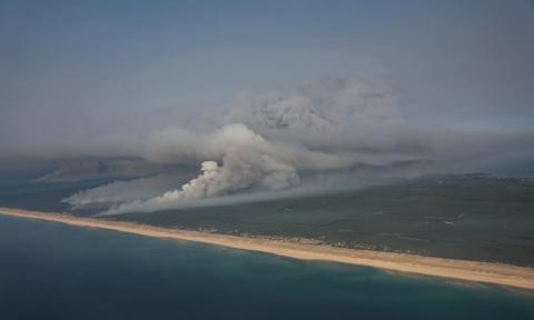
The barely studied phenomenon has been seen this summer in wildfires raging in the US, and for the first time ever in France.
The Naked Scientists: Probing pyrocumulonimbus: jet to fly through fire clouds
Fuelled by the hot, dry weather, wildfires are continuing to rage in many countries. In France and Spain, hundreds of thousands of tourists and locals have been evacuated, and winemakers in the Bordeaux region fear that smoke blowing in from the extensive fires is tainting grapes and ruining the season’s wine. In the UK, a fire on the east coast is heading for a nuclear power station, and the US and Canada are also on red alert with significant conflagrations. The thing about massive fires is that their awesome power means that they can effectively make their own weather, and one manifestation of this is the cloud phenomenon called pyrocumulonimbus: The intense heat and skyward ejection of ash and dust causes the formation of powerful thunderstorm systems above the fire. Unfortunately they don’t produce much if any rain, but they are capable of dramatically accelerating the fire through wind effects, and disseminating the fallout. Beyond that, we don’t much more than the hypothetical about how they operate and how to model them. That’s hopefully going to change with INSPYRE, a NASA-backed campaign sending a specially adapted jet bristling with sensors to chase and interrogate these fire clouds over the western US. Atmospheric chemist from the University of Utah, Derek Mallia, is one of the team…
CBS News: Research jet based in Colorado will chase wildfire smoke across the West
A research jet based in Broomfield, Colorado, will chase wildfire smoke across the West this summer, helping scientists understand how fires can create dangerous weather of their own.
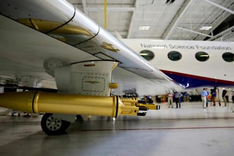
The Gulfstream V is managed by the National Science Foundation National Center for Atmospheric Research, or NSF NCAR. As part of NASA's INSPYRE mission, the jet will fly directly into smoke plumes and clouds created by wildfires.
Instruments inside the aircraft and on its wings will measure soot, gases, and cloud particles in real time.
UIowa: Iowa students join NASA mission to study wildfire clouds
The University of Iowa engineering students are helping researchers collect data on pyrocumulonimbus clouds formed by intense wildfires.
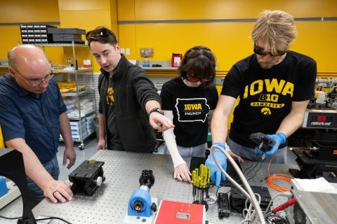
Engineering PhD student Grant Finneman is participating in a NASA field mission this summer, in a way that very few students will ever experience. He is part of a NASA project that is collecting data to better understand dangerous wildfire-generated pyrocumulonimbus clouds (called pyroCb). The INjected Smoke and PYRocumulonimbus Experiment (INSPYRE) is focused on understanding the fire and meteorological conditions that combine to generate pyroCb and the effects of pyroCb on the atmosphere.
The Iowa team relies on the Cloud Physics Lidar (CPL), an instrument mounted to NASA’s unique ER-2 high-altitude research aircraft, to collect data. Matthew McGill, PhD, professor of chemical and biochemical engineering, is leading the CPL operations — an instrument that he originally developed 25 years ago while at NASA. The team recently expanded its capabilities, including the ability to transmit data in real time using satellite downlink.
“This is a very unique opportunity for our students, as there are very few instruments like this,” said McGill. “Students learn first-hand how engineers and scientists work together to accomplish a shared mission, something most students don’t get to experience.”
Nature: First mission to fly through monstrous ‘fire clouds’ is about to take off
In a hangar in Broomfield, Colorado, a Gulfstream V jet plane is getting last-minute checks before it heads out on a daring mission. The aeroplane is part of a NASA campaign that will, for the first time, extensively sample ‘fire clouds’ — towering, mushroom-like formations that reach into Earth’s upper atmosphere above extremely large and hot wildfires, such as those now burning in France, Spain and the Pacific Northwest.
“We’re seeing these intense fires and unpredictable behaviours,” says Teresa Campos, an atmospheric chemist at the US National Center for Atmospheric Research (NCAR) in Boulder, Colorado, who works on the project. “It definitely feels like an important topic to be researching.”
So far, scientists have collected only one sample of fresh smoke in the stratosphere above a pyroCb. All other data come from research planes, flying for other purposes, doing ‘sniff tests’ to measure high-altitude smoke. “This time, it’s going to be more than a sniff,” Peterson says.
The INSPYRE researchers aim to fill in the remaining blanks. Given the explosive fire season under way in western North America, [Neil] Lareau, [an atmospheric scientist at the University of Nevada, Reno, who is leading the ground-sensing team], isn’t worried about finding fire clouds to sample. “For better or for worse, it looks like there are going to be a lot of targets,” he says.
Denver7: Towering 'firestorm clouds' are largely a mystery. A first-of-its kind NASA mission is working to change that.
BROOMFIELD, Colo. — Where there’s smoke, there’s fire. And sometimes, where there’s fire, there’s a towering pyrocumulonimbus cloud blasting that smoke high into the atmosphere.
Fire-generated thunderstorms — which scientists liken to powerful volcanoes that can shoot smoke 50,000 feet into the air — are the subject of a new, first-of-its-kind NASA research mission that will require a specially-outfitted, Broomfield-based NCAR plane to fly into the storms.
“Not only are we trying to predict which fires produce these storms, but also understand, once they inject smoke really high, what are the potential effects downstream,” Dave Peterson, the project’s principal investigator and a Naval Research Lab meteorologist, told Denver7.
Already in the Western U.S. this year, there have been 11 of these firestorm events, according to Peterson, with at least six of them occurring over Colorado wildfires.
9News: Broomfield-based researchers studying storms created by wildfires
Some wildfires don't just burn, they create their own thunderstorms. And now, a NASA-led mission based in Colorado is taking to the skies to figure out why.
"There are many parts of this that are still not well understood. There's only so much you can do looking from space with satellites, but at some point you actually have to get aircraft and go up there and measure it." [Dave Peterson]
Dave Peterson is preparing to do just that as NASA and partners prepare to fly high above wildfires to try and figure out how smoke and intense heat can produce thunderstorms.
[Taken from video transcript]
Broomfield Enterprise: Colorado-based NCAR plane will fly into firestorm clouds
NASA’s INjected Smoke and PYRocumulonimbus Experiment, or INSPYRE, is a five-year project to examine the type of severe weather generated directly by large wildfires. Through INSPYRE, NASA and its partners, including NCAR, will fly planes into fire-generated clouds, called pyrocumulonimbus, that can sometimes grow into full-sized thunderstorms resulting in lightning and tornadoes.
“So this phenomenon, it’s kind of a new scientific topic,” INSPYRE principal investigator Dave Peterson said during a media event on Tuesday. “It’s not well understood. It’s also not well predicted. And so we’ve assembled a very large group of scientists from many different agencies, universities and other collaborators to tackle this challenge.”
The experiment seeks to improve scientists’ understanding of the firestorm clouds, including which fires produce these storms and why. A deeper understanding could lead to better predictions for air quality, smoke and weather, helping to inform firefighting efforts and community response and resilience. Researchers will start analyzing data as they collect it.
“Anytime you’re studying fires, you’re trying to learn more about their behavior and what gets them going so that research can really focus on safety and health of the public,” said Cory Wolff, INSPYRE’s project manager at NCAR. “So we’re hoping that down the road, what comes out of this can really start to have impacts for the people here because we live with it most summers.”
NYT: Firefighters in France Encounter a ‘Fire Cloud’
In the devastating wildfires in France, officials said that firefighters had encountered a dangerous phenomenon that many of them had not seen before: a pyrocumulonimbus, or “fire cloud.”
These large, fire-fueled thunderstorms, also known as pyroCbs, are created by intense heat from large blazes or volcanic eruptions. They produce lightning and burning embers that can spark more fires, and they generate high and unpredictable winds that fan the flames and spread the embers. But they rarely bring rain.
One pyrocumulonimbus generated more blazes over the weekend in one of the hardest-hit areas of France, Marc Vermeulen, the director of fire and emergency services in the Gironde region, said at a news briefing on Sunday.
“These fire-generated clouds are linked to extreme fire behavior that impedes firefighting efforts and can devastate communities,” according to NASA, which emphasized the need to better understand the clouds “given the ongoing and projected increases in fire activity and severity.”
JPL: New NASA Earth Missions Gear Up to Start Science Flights
The first of six new venture-class missions will hit the skies this summer to chase dangerous and little understood pyrocumulonimbus storms out West.
Landslides in Alaska. Air quality in Atlanta. Fire clouds out West. From the Arctic fringes to farm country, NASA’s newest class of suborbital Earth Venture missions is gearing up to deliver science that will benefit communities in the United States and beyond...
The first project to take wing this summer is Injected Smoke and PYRocumulonimbus Experiment (INSPYRE), led by the Naval Research Laboratory. From mission headquarters in Colorado, the team will chase one of the least understood forms of severe weather on Earth: towering “fire clouds” generated when extreme wildfires burn hot enough to brew their own thunderstorms.
Smoky and crackling with lightning, these unique storms can create blind spots for aviators above and spark new blazes below. Measuring and mapping the dangerous storms as they develop in real-time will help scientists forecast them in the future. Several aircraft, including NASA’s high-altitude ER-2, flying out of Montana, will carry a large suite of instruments over wildfire-generated storm systems. Among them will be two state-of-the-art infrared wildfire trackers, which were developed at NASA’s Jet Propulsion Laboratory (JPL) in Southern California and will be flying as part of the agency’s FireSense program.
NRL News: NRL Leads NASA Wildfire Research Mission to Better Predict Pyrocumulonimbus Storm Hazards
The U.S. Naval Research Laboratory is leading a NASA airborne science mission to better understand dangerous wildfire-generated thunderstorms known as pyrocumulonimbus storms, or pyroCb, and the cascading hazards they create for firefighting operations, aviation, weather forecasting and national security.
“Pyrocumulonimbus is a unique type of severe weather linked specifically to wildfires,” said David Peterson, Ph.D., research meteorologist at NRL Monterey and principal investigator for INSPYRE. “Some of these storms produce significant lightning and others produce very little. We know that lightning can ignite new fires, but we don’t yet understand what drives those differences. INSPYRE gives us our first opportunity to study that process with a full suite of airborne lightning measurements.”
The mission, called the Injected Smoke and PYRocumulonimbus Experiment, or INSPYRE, is expected to deploy in midsummer 2026 and 2027, using NASA’s high-altitude ER-2 aircraft based in Great Falls, Montana, to study wildfire-driven storms across the western United States and parts of Canada. A second aircraft, NSF/NCAR’s Gulfstream V, will conduct in-situ sampling directly inside pyroCb plumes in 2026, while a ground team led by the University of Nevada, Reno will deploy mobile radar and lidar systems near active fires.
INSPYRE Outreach Inspires Future Scientists at Massachusetts High School
INSPYRE team member Jasna Pittman, part of the Harvard HUPCRS+ instrument team, recently visited Woburn Memorial High School to speak with approximately 40 tenth-grade physics students about airborne science, NASA research aircraft, and the ongoing work of the INSPYRE mission.
As budding future scientists, the students had an opportunity to see how a real-world Earth science mission operates and to learn about the many different pathways scientists, engineers, researchers, and support teams take to contribute to NASA missions and airborne field campaigns. Outreach opportunities like these help connect classroom learning to active scientific research and encourage students to imagine themselves pursuing future careers in STEM fields.
Students were excited to learn about the wide range of projects and career paths represented within NASA and INSPYRE, and were especially thrilled to receive NASA and INSPYRE outreach items provided by the ESPO team.
Following the visit, teachers shared the positive impression the presentation left on students and the excitement it generated around science and research careers. The response was so enthusiastic that Jasna has already been invited back to continue sharing mission updates and campaign experiences with the class.
For more information, contact Jasna Pittman.
NYT: 7 Takeaways From the Seemingly Endless Fire Season
The Line fire had burned through more than 21,000 acres of Southern California when officials announced Monday morning that it was only 3 percent contained. Amid record temperatures, the blaze quickly ate through dry vegetation, injuring three firefighters and leading to evacuation orders for more than 6,000 people across San Bernardino County.
It’s just one of 67 large wildfires currently burning across more than two million acres of the country. While the end of summer has typically meant a slowdown of major wildfires, climate change has upended that seasonal pattern.
So what’s different about today’s wildfire weather?