News

Satellite image of the islands and waterways that form the crux of the Northwest Passage acquired on July 13, 2024, by the Ocean Color Instrument aboard NASA’s PACE

Arctic Ice Won't Let Go: The Surprising Truth Behind the...

SciTechDaily - On July 13, 2024, the OCI (Ocean Color Instrument) aboard NASA’s PACE (Plankton, Aerosol, Cloud, ocean Ecosystem) satellite captur...

Read More

NASA's PACE Mission: Plankton, Aerosol, Cloud, ocean...

Remote sensing is the science of looking at objects from a distance. Applying the concept to satellites, we can look at any number of objects from spa...

YouTube
The mechanical team assembles in the clean room where they prepared the PACE Observatory before launch. (Photo: NASA)

A Vivid New View of Earth

Living on Earth - A powerful new NASA satellite called PACE can look at the ocean and clouds to distinguish between different kinds of microscopic ph...

Read More

Keeping PACE with the Oceans

NASA Goddard - Did you know that we can detect tiny organisms called phytoplankton from space?  These creatures affect the colors of the ocean, and ...

YouTube

NASA Leader Emphasizes Satellite Data and Collaboration to...

Via Satellite - NASA wants to play a key role alongside the commercial satellite industry to use satellite technology to help avert the climate cris...

Read More

PACE Makes the Invisible Visible

NASA Goddard - PACE, the Plankton, Aerosol, Cloud and ocean Ecosystem mission, views our entire planet every day, returning data at a cadence that all...

YouTube
Aerosols, as observed by PACE’s HARP2 and SPEXone instruments.

PACE Celebrates National Ocean Month With Colorful Views of the...

NASA - What do you give to an ocean that has everything? This year, for National Ocean Month, NASA’s Plankton, Aerosol, Cloud, ocean Ecosystem (PAC...

Read More

PACE-PAX

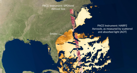
The Plankton, Aerosol, Cloud, ocean Ecosystem Postlaunch Airborne eXperiment (PACE-PAX) is a September, 2024, field campaign to gather data for the validation of the recently launched PACE mission. The operational area is Southern and Central California and nearby coastal regions. 84 flight hours are planned for NASA ER-2 operating out of the NASA Armstrong Flight Research Center and 60 for the CIRPAS Twin Otter flying out of Marina Municipal Airport. A NOAA vessel, the R/V Shearwater, will operate out of Santa Barbara. Flights will be coordinated between the aircraft, with PACE overflights, and with surface based observations including from the R/V Shearwater and other vessels and floats. A secondary objective is validation of observations by the recently launched ESA EarthCARE mission. Data will be made available within six months following the conclusion of the campaign.
 
More details are in our white paper and website.


PACE-PAX validation objectives
1. Validate new PACE and EarthCARE products
2. Provide sufficient data to validate narrow swath orbital observations
3. Validate radiometric and polarimetric properties
4. Focus on specific processes or phenomena


Mission Scientist: Kirk Knobelspiesse (NASA GSFC)
Deputy Mission Scientist: Brian Cairns (NASA GISS)
Deputy Mission Scientist: Ivona Cetinić (NASA GSFC)
Project Manager: Sommer Nicholas (NASA ARC)
Deputy Project Manager: Judy Alfter (NASA ARC)


PACE Project Scientist: Jeremy Werdell (NASA GSFC)
PACE Deputy Project Scientist: Brian Cairns (NASA GISS)
PACE Deputy Project Scientist: Antonio Mannino (NASA GSFC)
PACE Program Scientist: Laura Lorenzoni (NASA Headquarters)
PACE Deputy Program Scientist: Hal Maring (NASA Headquarters)
PACE Applications Program Lead: Woody Turner (NASA Headquarters)