
The TExas and FLorida UNderflights (TEFLUN) Experiment is a mission to obtain validation measurements for the Tropical Rain Measuring Mission (TRMM). TRMM is a NASA and National Space Development Agency of Japan (NASDA) coordinated mission that launched the TRMM satellite on 28 November 1997 with a unique complement of sensors to remotely observe rainfall throughout the global tropics. TEFLUN is the first in a series of experiments using a combination of airborne and surface-based measurements to complement the satellite data. Among these, are important measurements aboard the NASA high-altitude aircraft, similar to those on the TRMM satellite. They are used for direct intercomparisons with TRMM overflights where possible, but more frequently to simulate TRMM data by flying over precipitation systems within the experimental domain. These, along with in situ aircraft data, surface-based measurements and computer models, will make unique contributions to our understanding of the tropical precipitation spectrum.
TRMM field campaigns (FCs) aim at validation of the ground validation products derived from radars and rain gauges, TRMM-derived Levels 2 and 3 radiometer, rain and rain profile products, and vertical profiles of latent heating. Since latent heating profiles cannot be directly measured, numerical cloud models are used in TRMM algorithms to provide the link between the latent heating profiles, TRMM radar and radiometer observations. Consequently, an important part of the campaign is to provide comprehensive observations of the structure and evolution of Mesoscale Convective Systems (MCS), individual convective events, and their environment. Cloud and mesoscale models require these data sets for initialization and the subsequent model results must be validated for realism of vertical structure and latent heating. While the TRMM instantaneous and monthly algorithms can be evaluated through intercomparison with ground validation (GV) and other data sets, the campaigns will provide additional observations required for a more thorough validation and guidance for improving the algorithms.
TEFLUN-A will be conducted between April 1 and May 15, 1998, principally focused on the Texas ground validation site. The NASA ER-2 aircraft participation is planned for April 8 - May 8, 1998 based at Eglin AFB, FL. A cloud physics aircraft based within or near the TX site will also participate. There is close coordination with the Houston and other WSR-88Ds, the Texas A&M ADRAD Doppler radar, the NOAA ETL X-band polarization radar (X- POL), and the NOAA AL Profiler system. These ground-based facilities are integrated with dense rain gauge networks and disdrometers. Soundings will be obtained from two mobile systems to provide initialization and validation data for models at strategic times and locations.
TEFLUN-B will be conducted between 1 August and 30 September 1998, principally focused on the Florida ground validation site. ((DC-8 actually arrives around the 10th)) It will be conducted in close coordination with the 3rd Convection And Moisture Experiment (CAMEX-3), both involving NASA ER-2 and DC-8 aircraft, and a cloud physics aircraft, all based at Patrick AFB, FL. There is close coordination with the Melbourne and other WSR-88Ds, the NCAR S-band polarization radar (S-POL) radar, the array of facilities at the Kennedy Space Center, and the NOAA AL Profiler system. Soundings will be obtained from two mobile systems to provide initialization and validation data for models at strategic times and locations. A dense network of ground-based facilities measurements will also be utilized in TEFLUN-B.
A few key web sites for TEFLUN-A and TEFLUN-B are:
| TEFLUN Project | http://cloud1.arc.nasa.gov/teflun/ |
| CAMEX-3 Project | http://wwwghrc.msfc.nasa.gov/camex3/ |
| TEFLUN-A (Texas A&M) | http://www.met.tamu.edu/research/teflun.html |
| TEFLUN-B (TRMM Office) | http://trmm.gsfc.ansa.gov/trmm_office/field_campaigns/teflun/teflunb/teflunb_gv.html |
| TEFLUN Data Archive (GSFC DAAC) | http://daac.gsfc.nasa.gov/CAMPAIGN_DOCS/TEFLUN/teflun.html |
It is emphasized that when responsibilities are indicated below, that it is possible to fulfil these by delegating them to others, if appropriate.
NASA Program Director (Kakar). Overall responsibility for program, personnel, and resources. Flight hour allocation, budgets, interaction with NASA HQ. Overall decision-making authority.
NASA Aircraft Operations Director (Shelton). Aircraft facility management, safety, instrumentation, status reporting, ultimate flight decision authority.
NASA Project Manager (Craig). Responsible for overall science/aircraft coordination, host relations, security, facilities, flight schedule updates, communication/network, TEFLUN handbook and web page.
Field Program Director (FPD) (Heymsfield). Responsible for achieving overall scientific goals and for overall scientific direction. Convenes meetings of scientific advisory group. Makes each day's decision (normally with concurrence of NASA Program Director) on forthcoming days status: Operational, alert, or hard down day. Appoints Mission Scientist(s).
[Note: For TEFLUN-B, conducted in conjunction with Convection and Moisture Experiment-3 (CAMEX-3), there are separate positions for TEFLUN-B FPD (Heymsfield) and CAMEX-3 FPD (Hood). As currently envisioned, the CAMEX- 3 FPD chairs the scientific advisory meeting, which includes both CAMEX-3 and TEFLUN PIs, as well as being the principal interface with the NOAA Hurricane Research Division (HRD) and AOC for all tropical cyclone missions, including any WRP missions in landfalling cyclones.]
Science Advisory Group. Consists of all scientific stakeholders, mostly the PIs but could include others. In TEFLUN-A this may be a fairly small group but in TEFLUN-B/CAMEX-3 it will be larger. Individuals will report status of their part of the program, PI instrument status, and recommend the next days strategy keeping in mind the overall goals. Chaired by the FPD.
Mission Scientist(s). This person(s) is appointed daily for the following days missions. Heymsfield, Hood, Zipser and others would be appointees. Responsibilities include:
Data Manager (TBD). Responsible for all TRMM documentation, status reporting, status board, telephone, and TRMM web site updates. Assure documentation and debriefing after all missions; maintenance of logs; producing operations report soon after end of field phase, interface with TSDIS and DAAC.
Lead Forecaster. Coordination of forecasting for daily meetings, near-time updates for pilot briefings, and real-time radar and satellite products for assisting Mission Scientist and Pilots to make in-flight decisions.
There will be a planning meeting daily. The timing will be determined by the lead time requirements for the aircraft alerts on the following day. There will be status reports from the FPD, Aircraft Operations, weather briefings, and recommendations from the science advisory group. Goal is a consensus on next days operational status, goals, and strategy, primary and alternate missions, deployment of ground-based personnel.
Decisions on next days operations, staffing for all aspects of the next days
operations, and outlook for the following several days, will be announced by the
Project Manager immediately after this meeting, and posted for quick access by
all interested personnel.
(( Notifications are posted around labs, hotel, sent via email, and posted on web page. ))
The mission objectives and flight scenarios decided on the previous day are weather-dependent. Because forecasts of these convective and mesoscale weather events will be imperfect, and sometimes quite wrong, a successful mission requires the capability for certain adjustments to the evolving weather situation. These are divided into two parts, preflight and during flight. At the time of pre-flight briefings, 3-4 hours prior to the ER-2 takeoff, the task is to update the previous days forecast of the target weather, with the daunting challenge of a 4-10 hour forecast. For the cloud physics aircraft, (SPEC Lear or :UND Citation), the pre-flight update can be delayed until 30-60 minutes before takeoff, but it still requires a 1-5 hour forecast.
The preflight briefings and any necessary adjustments to the flight scenarios are the responsibility of the Mission Scientist, who will be assisted by the lead forecaster or designee (staffing per previous day's decision). It is possible at this time that a planned mission could be canceled, or shifted to an alternate mission, or the location of the target changed, if circumstances dictate.
Once a project aircraft is airborne, it is the responsibility of the Mission Scientist, who will be assisted by the lead forecaster or designee, to closely monitor the progress of the mission. Mindful of the difficulty of making changes to the flight lines after takeoff, any recommended in-flight adjustments will be made through the FPD or the mission scientist, and through pre-determined communication channels. If pre-mission planning is carefully carried out, relatively small adjustments to assure that actual aircraft tracks are properly placed with respect to the actual weather events should be possible. Details of the acquisition of weather information from satellites and radars must be planned in advance, as well as the optimum channels of communication. The principle to be followed is that the fine-tuning of aircraft tracks should be based on the best weather information for the given situation. For some situations this will be on board the ER-2; for some it will be from those ground-based radars in Texas or Florida; for some it will be from displays of satellite data.
Adjustments during the mission are not only to the aircraft tracks. The surface- based sounding systems must be properly positioned with respect to the target weather event(s), and the radar scanning strategies must be closely coordinated with the satellite and aircraft tracks. It is the responsibility of the Mission Scientist to monitor and make optimum use of all observing systems.
The ER-2 during TEFLUN-A and TEFLUN-B, and the DC-8 during TEFLUN-B, will carry instruments associated with TRMM objectives. The instruments most relevant to TRMM are a subset of the payloads carried by each aircraft.
ER-2 Doppler Radar (EDOP) is a dual-beam 9.6 GHz Doppler radar that will provide vertical profiles of reflectivity, vertical hydrometeor motions, horizontal winds along the aircraft track, and polarization measurements which provide microphysical information. This instrument will be used to examine vertical precipitation structure and resolution limitations of the PR.
Advanced Microwave Precipitation Radiometer (AMPR), with frequencies similar to TMI (10 - 85 GHz), will provide information on precipitation structure through the rain emission and ice scattering signals.
Lightning Instrument Package (LIP) provides measurements of the three- dimensional electric field and conductivity. This information will be related to the LIS measurements on the TRMM satellite.
Multispectral Atmospheric Mapping Sounder (MAMS) provides high resolution mapping with 11 channels visible, near-IR, and IR a 6.7 m moisture channel similar to that flown on GOES.
MODIS Airborne Simulator (MAS) provides high resolution visible, near-IR, and IR imagery over 50 channels. [Note, MAMS will be flown in TEFLUN-A and TEFLUN-B will be split between MAMS or MAS.]
ER-2 High-Altitude Dropsonde (EHAD) is a new experimental dropsonde system that will fly for the first time during TEFLUN-B.
Millimeter Imaging Radiometer (MIR) is a cross-scanning radiometer at frequencies from 90 GHz to 325 GHz.
There are several other important ER-2 instruments that will fly during TEFLUN-A and B including Submillimeter Limb Sounder (SLS), (NAST-I) and (NAST-M), and telemetry using STARLINK.
Airborne Rain Mapping Radar (ARMAR) simulates the TRMM Precipitation Radar (i.e., 14 GHz frequency and cross-track scanning). It provides information on the three-dimensional structure of reflectivity and hydrometeor motions, as well as polarization and Doppler measurements.
Polarimetric Scanning Radiometer (PSR) is a new conical scanning radiometer at the TRMM Microwave Imager frequencies, and for the first time, provides a closer simulation to the SSM/I and TMI conical scanning and polarization measurements.
Airborne Multichannel Microwave Radiometer (AMMR) is a suite of fixed-beam radiometers GHz that will be used to help understand microwave emission from rain. It will have channels at 18 and 37 GHz (up-looking) and 37 GHz (nadir- looking).
Lightning Instrument Package (LIP) provides measurements of the three- dimensional electric field and conductivity.
Cloud/Aerosol Particle Characterization (CAPAC) provides microphysical information using Particle Measurement Systems 2D-C, 2D-P, and FSSP probes.
Dropsondes will be launched using the GPS system developed by National Center for Atmospheric Research.
There are several additional instruments that will be flown on the DC-8 as part of CAMEX-3. These instruments will provide valuable information for the TRMM objectives.
More detailed descriptions of the full ER-2 and DC-8 instrument complements for TEFLUN-A and TEFLUN-B/CAMEX-3 are given on the TEFLUN-A/B and CAMEX3 web sites: TEFLUN-A/B: http://cloud1.arc.nasa.gov/espo/teflun CAMEX-3: http://www.ghrc.msfc.nasa.gov/camex3
The following describes seven flight scenarios (Scenarios 1-7) which address the goals of the TEFLUN-A and TEFLUN-B campaigns. TEFLUN-A will have two aircraft [ER-2 and cloud physics aircraft (CP)] and flight plans are shown in Flight Scenarios 1-7. TEFLUN-B will have three aircraft [ER-2, DC-8, and CP]. The intent here is to provide a set of flight scenarios which satisfy the TRMM objectives, but also which operate within the flight safety constraints of the aircraft. The flight scenarios presented are for three aircraft, with the expectation of situations where ony one or two aircraft are available. The three aircraft flight scenarios presented can be adjusted for fewer aircraft. The timing characteristics, evolution, and movement of precipitation systems will differ between TEFLUN-A and TEFLUN-B. Regardless of these differences, the TEFLUN-A and TEFLUN-B flight objectives are not significantly different. What will be different is the relative frequency of different weather patterns and consequent flight scenarios.
Note that Scenarios 1 to 5 are strongly tied to a precipitation event, with effort to maximize coordination with the ground-based measurements, and TRMM overpasses. Of highest priority for TRMM FCs is to maximize coincidence between the satellite, aircraft, and ground-based measurements. It is clear that the probability of obtaining ALL these measurements during a precipitation event and over the enhanced Texas GV network during TEFLUN-A, and the Florida GV network during TEFLUN-B. Decisions will have to be made on a case by case basis as to whether the available resources will provide scientifically important data. Thus, the ER-2, DC-8, and CP aircraft may at times be operated independently of a TRMM overpass. Scenario 6 requires coincidence of the ER-2 or DC-8 and TRMM; coincidence with other facilities such as the CP and ground-based radars is highly desirable. Scenario 7 is radar dependent, i.e., the ER-2, DC-8, and CP will fly radar radials. For TEFLUN-A, the possible radars are the Houston WSR-88D, NOAA AL profiler, X-POL, combination, ADRAD, or if necessary, another WSR-88D (Corpus Christi, Lake Charles, New Braunfels, or Granger). For TEFLUN-B, the possible radars are the Melbourne WSR-88D, the NOAA AL profiler, S-POL, combination, or if necessary, another WSR-88D (Miami, Tampa, Key West).
Safety Concerns: The flight scenarios presented are conceptual and their implementation depends on real-time decisions concerning aircraft safety. While TRMM desires measurements within convective and stratiform precipitation regions, the DC-8 and CP will not be directed through any cells with indications of high reflectivities, hail, or strong updrafts. The ER-2 may still be directed over intense convection depending on the particular case.
Flight Clearances: Flight clearances may be difficult to obtain for some of the flight scenarios, patricularly ones focusing on lower altitudes. If flight clearances are not given, then the flight profile may have to be modified significantly from that shown in the flight scenario. These decisions will be made on a real-time basis and may prebent close coordination of the aircraft.
Many MCS's appear as a leading convective line and a trailing stratiform reagion, sometines with a transition zone between them. These systems are of particular interest to TRMM because the latent heating profiles differ greatly between stratiform, convective, and transition regions. Climatology suggests that this type of MCS is more common during TEFLUN-A than during TEFLUN-B. Combination of diverse aircraft and surface data sets will help improve model physics and understanding the comples relations between clou microphysics, microwave radiances, and latent heating. Also, the measurements will enable examination of issues such as the relation between cloud electrification, ice mass, updraft strength, and 85 GHz grightness tempratures.
The goal of this flight scenario is to provide coverage of the evolution of the 3-D structure of a squall line system for model validation, with as many of the available supporting observations as possible. The ER-2 will perform lines normal to the squall line, covering the convective and stratiform regions. The DC-8 and CP will perform coordinated flight lines with the ER-2 when possible due to safety considerations. This will most likely involve weak squall lines. Both DC-8 and CP will collect microphysical information under the ER-2, and the DC-8 will also collect remote sensing data (i.e. radar and radiometer). At other times when the convection is too strong for safe aircraft operation, the DC-8 and CP will fly a racetrack in the trailing stratiform reagion. The CP will fly this pattern descending to lower altitudes in the stratiform region to collect vertical profiles of microphysical information.
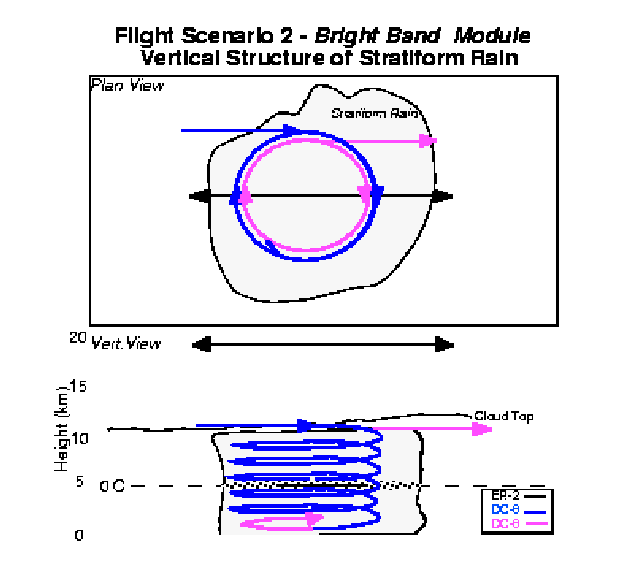
OBJECTIVES: To determine the microwave emission from the radar bright band. The radar and the radiometer communities currently model the absorption (and concomitant emission) of the bright band differently. These modeling approaches are important for physically-based raingall retrievals from either the radiometer or the radar on TRMM. But the merit of the different approaches are not well validated against observations. This flight module is aimed at stratiform regions with rain rates of 2-10 mm/hr. It can be performed with the DC-8 only which will have up and down-looking 21 & 37 GHz radiometers. Cloud microphysics instruments state parameter measurements (static air temperature, dew/frost point, etc.). ARMAR and the PSR. The ER-2 could also participate since it would provide a broader picture of the precipitation region. The DC-8 would preferably be within range of one of the WSR-88D radats or S-Pol which could provide guidance for locating startiform regions.
FLIGHT MODULE: The DC-8 would spiral down through the stratiform region with a size of at least 10 X 20 nm and preferably over an ocean background. From normal cruising altitude (anywhere above the -10C isotherm). The DC-8 would spiral down as quickly as possible to the -2C isotherm and reconfirm the presence of the bright band: the descent would be terminated if the rain has dissipated. The descent would then be continued to about the +15C isotherm and then circle in the rain until windows on microphysics probes are clear (these will fog during descent). Then the DC-8 would spiral ascent standard rate turns (at 300 kts this would make a 10 NM circumgerence (3NM dia) circle) at 2000 fpm to above the -3C level, and return to normal cruise altitude. The changing bank angle (as would be needed to make standard rate turns with a changing TAS) can be handled readily in data analysis.
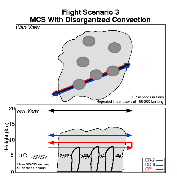
MCSs are often observed which are more complex than linear squall line systems. We can expect these in both TEFLUN-A and TEFLUN-B. The goals of this flight scenario are similar to Scenario 1. The three aircraft would be stacked and perform flight lines along the convective cells. The intensity of the cells will vary from system to system. There will be situations where the convective cells are weak and present no danger to the DC-8 or CP. These are the preferred situations. There will be other cases where the individual convective storms will be too strong for either the DC-8 or the CP. In these situations, alternative, safer flight plans will be given for the DC-8 and CP. The ER-2 may still be requested to fly over the active convective regions, since both the radar and radiometer measurements would be most userful.

The FCs will ideally collect data from thunderstorms in different stages of evolution, intensity, and geographical locations. Isolated thunderstorms may be present during either TEFLUN-A or B, but are more likely during TEFLUN-B over the Florida peninsula. Individual thunderstorms are simpler to model numerically, and it is often easier to obtain representative environmental conditions. Often, isolated thunderstorms do not have well developed anvils or stratiform regions. Consequently, the latent heating profiles may be different than typical tropical systems which have considerable stratiform rain. Because thunderstorms often have small dimensions relative to TRMM footprints, they can present beamfilling problems for TRMM algorithms. This flight scenario is aimed at isolated thunderstorms that are identifiable by the ER-2 pilots and do not have significant anvil ice present.
The main goal of this scenario is examine the relation between thunderstorm evolution, microwave brightness temperatures, vertical structure of reflectivity and updrafts, electrical activity, and relative amount of supercooled water and large ice aloft, and surface rainfall. This scenario requires repeated bow tie flight patterns with short flight legs, covering the evolution of the thunderstorm. The DC-8 and CP would fly similar patterns if entry into the convection was within safe limits.

Multicell thunderstorms have cells in various stages of development with the growing cells on the upwind end, and the decaying cells on the downwind end. This situation will be common during the TEFLUN-B Florida component, and it is very common in the tropics. The individual cells have short lifetimes (approximately 20 minutes), and are occasionally (butmost often not) intense. Flights over cells in varying stages of evolution are very important for TRMM objectives. The microwave brightness tempratures from which the vertical hydrometeor profiles are derived, are highly dependent on the stage of development of the cells. Young cells consist mostly of supercooled water above the freezing level without significant ice aloft, and rainfall is low. Mature cells have significant ice aloft and rainfall. Dissipating cells have highest rainrates at the surface with a reduction in ice aloft. And decayed cells move off into the anvil. Thus, there can be a time delay between the heaviest rainfall and the coldest 85 GHz microwave temperatures measured from above. The 85 GHz ice scattering-based channel, is the most useful channel for rain detection over land. Cloud microphysics measurements in the ice region are especially important for validation of model ice parameterizations, and for determining radiometric responses.
The flight lines for this scenario are linear tracks over the cells and anvil associated with this relatively small system. The three aircraft are stacked, and the CP will fly at higher levels (7-10 km). If the cells are weak, the CP will fly at multiple altitudes to map out the vertical microphysical structure.

This scenario is aimed at cordinating the ER-2, DC-8, and CP with a TRMM overpass. Coordination of the aircraft and overpass may require locating away from the augmented surface observations and soundings, but possibly within range of a WSR-88D. The goal of this scenario is:
Both the EDOP-AMPR combination on the ER-2, and the ARMAR-PSR combination on the DC-8, provide high-resolution measurements that can be used to examine (1). EDPO is an X-band radar which is much less attenuated than ARMAR or the PR and it can be used as a reference for the PR corrections.
For this scenario, the aircraft would begin a track a few minutes before the projected time of the TRMM overpass at that point so that the time of coincidence would be roughly mid-point of the flight line. This is the best coincidence that can be obtained given that TRMM is traveling at such a rapid velocity and the aircraft are traveling relatively slowly. The TRMM PR swath is about 220 km so that the flight line can be oriented along the precipitation region rather than the TRMM subpoint (the figure shows the aircraft track along the TRMM subpoint). The CP would perform an ascent or descent through the region. Both land-based and ocean cases are of interest for this scenario, and precipitation systems which cover both land and water background are of particular interest. These measurements would provide guidance for algorithm improvements for the difficult case of land backgrounds.
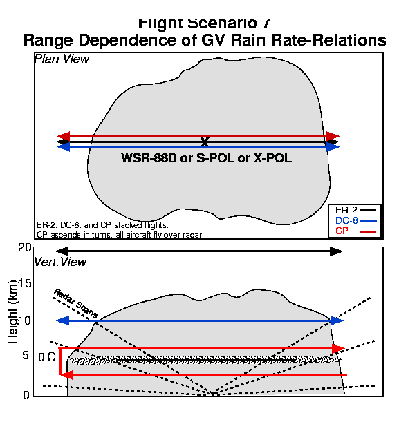
The Z-R relations used to convert radar reflectivity to rain rates have uncertainties due to their dependence on particle size distributions. In addition, the increase in radar beam size with distance from the radar, introduces further uncertainty. The size dependence issue will in part be addressed by flight lines of the type described in Scenario 2 which are not necessarily tied to a GV radar. The goal of the flight lines here are to examine the range dependence of the Z-R relations. This scenario will focus on ER-2 and DC-8 flight lines of about 200-300 km in length directed along radar radials and crossing directly over the radar. The ADRAD, X-POL, or S-POL radars will provide RHIs coordinated with the ER-2 and DC-8; or in the case of the WSR-88D, vertical structure will be reconstructed along the aircraft track from PPIs. The CP is highly desirable in the rain layer at several levels including the rain region, if possible. The Doppler/polarization radars on both the ER-2 and DC-8 can provide some information on the characteristics of the rain, but ideally the CP aircraft would provide information on the particle size distribution over the radar range interval.
Surface-based facilities which will form part of the database for TEFLUN-A include the Houston and other WSR-88Ds, the Texas A&M ADRAD Doppler radar, the NOAA ETL X-band polarization radar (X-POL), and the NOAA AL Profiler system. These ground-based facilities are integrated with dense rain gauge networks and disdrometers. Soundings will be obtained from two mobile systems to provide initialization and validation data for models at strategic times and locations. The TEFLUN-A surface network is shown in the following figure.

The operational mode for surface-based facilities will be contiunous for some and episodic for others. The WSR-88Ds, rain gauges, disdrometers, and profilers will operate continuously. The other surface radars (X-POL in TEFLUN-A, S-POL in TEFLUN-B) will operate either continuously, or whenever precipitation is within a 150 km range, assuming personnel requirements are met. The mobile soundings will be available to provide data for all significant precipitation systems, all events for which aircraft flights are anticipated, and all TRMM overpasses.
A more detailed description can be found at the Texas A&M web site given earlier.
The NOAA Aeronomy Laboratory will operate two vertically-looking doppler radar profilers for TEFLUN A and B. The two profilers will be colocated and operate at 915 MHz and 2835 MHz, respectively. The profilers are designed to observe precipitation with excellent vertical and temporal resolution. Doppler spectra recorded at each range gate are processed to yield equivalent reflectivity, Doppler velocity and spectral width.
The primary data product from the profilers are time-height sections of equivalent reflectivity and Doppler velocity. the two collocated profilers facilitate the unambiguous identification of vertical air motion and hydrometeor fall velocities in the Doppler spectra. During TEFLUN-A, the two profilers will be located in South Houston surrounded by a network of rain gauges. Disdrometers will be collocated with the profilers to measure drop-size distributions at the surface. In TEFLUN-B, the AL profilers will be located under the western lobe of the dual Doppler pair formed by the Melbourne WSR-88D and the NCAR S-pol radar.
Surface-based facilities which will form part of the database for TeFLUN-B incllude the Melbourne and other WSR-88Ds, the NCAR S-band polarization radar (S-POL), the array of facilities at the Kennedy Space Center, and the NOAA AL Profiler system. These ground-based facilities are integrated with dense rain gauge networks and disdrometers. Soundings will be obtained from the same two mobile as used for TEFLUN-A. The enhanced surface network for TEFLUN-B is shown in the following figure:

In addition to the enhanced TEFLUN-B surface network near the S-POL radar, the TRMM Florida GV network with the WSR-88D's will also be used as part of the flight region for the aircraft. This network covers most of Florida and is shown in the following figure:

A more detailed description of the TEFLUN-B GV network can be found at the TRMM
Office web site:
http://trmm.gsfc.nasa.gov/trmm_office/field_campaigns/teflun/teflunb/teflunb_gv.html
Overview:
In 1996 the Natiional Center for Atmosphereic Research (NCAR) began a program in radar hydrology and in particle discrimination. Hydrological goals are to improve Z-R relationship technology for estimating precipitation and to evaluate the potential of dual-polarization measurements for estimating precipitation. Other programmatic goals seek to develop techniq;yes for the remote detection of precipitation particle types (raindrops, snow crystals, graupel, and hail).
The corner stone of the program is NCAR's S-band, dual-polarization radar (S-POL).
Measureables include radar reflectivity, differential reflectivity, differential
propagation phase, the correlation coefficient between reflectivity an hoizontal
and vertical polarization, the linear depolarization ratio, and the radial
velocity. More details concerning the radar can be found at:
Http://www.atd.ucar.edu/rsf/spol/spol.html
S-Pol will be located at longitude 80° 44.736 min and latitude 27° 53.360' (200° and 26 km from the WSR-88D at Melbourne) and will operate from approximately 20 July until 30 September 1998. Operations will be conducted whenever precipitation is observed or forecast within the S-Pol umbrella. It is expected that a large number of hydrologic events will be collected. In addition S-Pol will support TRMM activities. A number of realtime products are available. Precipitation estimates (maps) are generated from radar reflectivity, specific differential phase, a combination of differential reflectivity and reflectivity, and from a combination of all three polarimetric variables. Accumulation times can be as short as ten minutes and as long as storm duration. There is a realtime hail detection algorithm. A recent addition is a particle discrimination product which will make designations in eleven categories. All realtime products are archived on tape for perusal.
Scanning Strategies:For hydrological experiments S-Pol will be operated in full PPI or sector mode. A number of experiments are planned:
The radar can be operated in either sector or vertical cross-section modes. Antenna speeds are 6.5°/sec in sector mode and 3-4°/sec in RHI mode. Data collections are flexible in terms of sector and elevation limits. Some examples with approximate scan durations are:
An RHI scan for an azimuthal sector of 30°, with elevation angles from 0 to 40°, and an azimuthal increment of 1° will take 6 min 40 sec at an antenna speed of 3°/sec and 5 min at 4°/sec. Full RHI's (horizon-zenith-horizon) are not possible. A proxy can be accomplished by stringing two RHI scans with elevation angles of 0 to 85° and a null sector width. Such a scan will take approximately 1 min 15 sec to complete.
The Iowa Institute of Hydraulic Research (IIHR) of the University of Iowa,
operates the so-called Mobile Rainfall Observatory, which includes a trailer-based
vertically pointing X-band radar (owned jointly with the Hydrologic Research Center
of san Diego, California), a 2-D video disrrometer, dual-design tipping-bucket
raingages, and other surface meteorological instruments. The instrumentation is
described below. Pictures of the instrumentation appear on the web at:
http://www.iihr.uiowa.edu/trailer/
The basic specifications of the vertically pointing radar are shown in Table 1. The radar was built at the McGill Radar Weather Observatory, McGill University, Canada. The microwave part of the radar is essentially a widely-used navigation radar manufactured by Decca. It is controlled by a PC equipped with a PCIP-SCOPE digital oscilloscope card, maunfactured by Keithly Metrab;yte, and software written by the developers of the radar at McGill University. The radar data acquisition software provides a rudimentary display program that is useful for confirming operation of the radar. Additional C library routines that enable reading, plotting, converting the data to a format that is easier to distribute, and analyzing the data, has been developed at IIHR. Recently, the radar was upgraded to Doppler capability using a PIRAC card developed at NCAR.
| Parameter | Value |
|---|---|
| Wavelength/Frequency | 3.2 cm (9410 MHz ± 30 MHz) |
| Peak power | 25 kW |
| Dish diameter | 1.2 m |
| Pulse length | 250 ns |
| Pulse repetition frequency | 1300 Hz |
| Pulses averaged | 1200 |
| Minimum height | 100 m |
| Maximum height | 8000 m |
| Bin size | 15 m |
IIHR's video disdrometer is one of only a handfull of such instruments worldwide. It was specially manufactured for IIHR by Johanneum Research at The Institute for Applied Systems Technology, Inffeldgrasse, Austria. Two light sources generate orthogonal light sheets that are projected through narrow slits onto two line scan cameras. The optics are designed so that, seen through the camera lens, the slits appear evenly and brightly lit. Particles falling through the beams of light appear as dark silhouettes against this background. The light sources and cameras form the sensor unit that is exposed to the precipitation.
The electronics and embedded computer that control the cameras and record the slit images are housed in a separate, weatherproof outdoor electronics unit. A second, indoor, PC communicates with this embedded computer via TCP/IP protocols. After copying the raw image information from the outdoor unit, the software running on the indoor PC reconstructs the shapes of the hydrometeros. The software also estimates the falling velocity, horizontal velocity, oblateness, and equivalent water content, for each individual hydrometeor. In addition to this information, aggregate information such as drop size distribution, rainrate versus time, vertical velocity versus time, oblateness versus diameter, etc. are computed and displayed in real-time. IIHR's disdrometer has been in operation since the middle of summer 1997, and we have collected data and written software to facilitate off-line analysis.
The instruments described above (i.e. vertically pointing radar, raingauges, and 2-D video disdrometer) are carried around on a 16 ft. trailer, called IIHR Mobile Rainfall Observatory. The trailer permanently houses the vertically pointing radar and accommodates the on-site data collection by the 2-D video disdrometer. For the raingauges, it merely serves as a hauling platform, but it houses the data acquisition and power distribution system too. We do not recommend, due to safety reasons, operating the radar while the trailer is in motion.
The trailer is outfitted with a dual voltage electric wiring (12V DC and 120V AC). This way an external power supply can be provided by a cable from a permanent facility, or from a diesel powered generator or a set of batteries. On-site computer data acquisition system allows long term operation and storage of large volume of data. The radar antenna is covered with a fiberglass dome, which mitigates the effect of attenuation by the layer of water collected on the cover during rainfall.
There will be approximately 30 rain gauges deployed in two separate clusters. Approximately 10 rain gauges will be installed at existing field mill sites within Kennedy Space Center (KSC). These rain gauges will enhance the existing network at KSC. Because the average gauge spacing is ~5km, the information provided by the KSC rain gauge network will help determine the mesoscale variabilith of rainfall across Cape Canaveral and provide ground truth for scanning radar. Indeed, the KSC rain gauge network is currently used to calibrate radar reflectivity (Z) - rainfall (R) estimates of rainfall for TRMM from the Melbourne NEXRAD.
The spacing of the KSC gauges is too course to provide detailed statistics of rainfall at the convective scale in TEFLUN-B. Also, it was recognized that there exists a signigicant amount of restricted airspace in the vicinity of KSC, thus hampering the ability of aircraft to sample convection in this area. Because an important component of TR<< TEFLUN B is to provide combined aircraft and ground-based sampling of Florida convection, an additional site was selected for the placement of a dense rain gauge network (DRGN). A tentative site for the DRGN was chosen near the town of Hollopaw, Fl. These gauges will be used to examine variability of raingall at 0.5-2.0 km scales and should provide information on the range-dependency of scanning radar Z-R estimates of rainfall (as well as Z_DR-R, K_DP-R and other polarimetric relations). Moreover, profiler-pair will be able to provide vertical structure information on the precipitation characteristics (including drop size distributions) that can serve as calibration for the scanning radars. The combination of the DRGN, profiler and scanning radars will provide a unique picture of the vertical and horizontal variability during the TEFLUN B campaign.
The rain gauges are tipping bucket type (Qualimetric). Details on the resolution and other characteristics of the gauges can be provided by Brad Fisher of the TRMM office.
A number of disdrometers will also be deployed as part of the TEFLUN B ground validation program. Three types of disdrometers will be used: 2-D video, Joss, and APL. The 2-D and Joss will be deployed at the profiler site in conjunction with an APL and a tipping bucket rain gauge. The purpose of having all 3 disdrometer types at the profiler types will be to not only compare the surface based measurements of drop size distribution characteristics with the vertical structure (profiler), but also to compare the surface measurements collected by each disdrometer to address the strengths and weaknesses of each unit (address low end sensitivity of the APL disrometer).
Approximately 5-10 additional APL disdrometers will be used in TEFLUN B. These disdrometers represent a new technology in disdrometer design. They are capable of storing several weeks of data at a time and will be stand-alone units. However, it should be noted that these systems are relatively new (being only deployed in TEFLUN A) and their reliability is not known. Also, as it currently stands, the low-end sensitivity of the APL disdrometer is approximately 1 mm and may therefore bias the retrieved DSD characteristics.
The UND Cessna Citation II aircraft (see front cover) has a number of design and performance characteristics which make it a versatile and comparatively low cost platform for a wide range of atmospheric studies. The Citation II is a twin engine fanjet with an operating ceiling of 43,000 feet (12.1 km). The turbofan engines provide sufficient power to cruise at speeds of up to 340 knots (175 m/s) or climb at 3300 feet/min (16.8 m/s). The fanjet engines have relatively low fuel consumption at all altitudes, giving the Citation an on-station time of up to 4 hours or more, depending on mission type. Long wings allow it to be operated out of relatively short airstrips and to be flown at ths slower speeds (140 kts or 72 m/s) necessary for many types of measurements. The Citation is certified for flight into known icing conditions.
The cabin measures approximately five feet in diameter and more than 16 feet in length. The minimum flight crew is pilot, co-pilot and data system operator. Two additional seats are avbailable for scientific observers.
A series of structural modifications have been made to the basic airplane including the following:
More details about the UND Citation can be found at:
http://www.aero.und.edu/ATS/citation.html
The basic instrumentation package measures temperature, dew point temperature, pressure, wind and cloud microphysical characteristics along with aircraft position, attitude and performance parameters. The three dimensional wind field is derived from measurements of acceleration, pitch, roll and yaw combined with angles of attack and sideslip and indicated airspeed. An LTN-76 inertial navigation system and a global positioning system (GPS) supply the aircraft parameters. Turbulence intensity can be derived from differential pressure transducers and accelerometer outputs. Cloud microphysical measurements are made with an array of Particle Measuring Systems probes (FSSP, 1D-C, 2D-C, 1D-P) mounted on the wing tip pylons. These probes measure concentrations and sizes of particles from one µ to several millimeters in diameter. In addition, there are probes to measure both liquid water content (CSIRO) and icing rate (Rosemount icing meter). For TRMM two new instruments will be available, a Cloud Particle Imager (CPI) and a High Volume Particle Sampler (HVPS), both from SPEC, Inc. These will provide improved resolution above that which is achieved from the PMS probes. The CPI will provide microscopic quality images of small ice particles. The HVPS will replace the 1D-C probe and it will provide improved sample volumn for detection and imaging of large particles. A PMS 2D-P probe may also be used for periods when the HVPS is not available.
A forward or side-looking video camera is also used to provide a vbisual record of flight conditions and for recording of cockpit conversation. A Bendix-King vertical profiling forward looking weather radar can be viewed in the conkpit and recorded on videotape.
Data Acquisition and Display:The data collected by the Citaiton can be sampled at various rates from 1 to 25 Hz. The sampling is controlled by the on-board computer system, which also displays the data in real time in graphic and alphanumeric formats while recording them on magnetic tape. The data system is based on a projetc-customized windows system to allow flexibility in data acquisition and instrumentation in order to accommodate specific research demands. The data system and power distribution systems were upgraded during 1996, which produced a substantial improvement in flexibility. also, an improved version of the data system was leased and adapted to fit the instruments. This provided a significant gain in weight and power availability.
When in the field, the Citation is accompained by a mobile operations support trailer. This vehicle houses thchnical support facilities, including calibration equipment for on-site quality control, and a workstation/ minicomputer system. The meteorological data collected on a research flight can thus be processed and examined within 24 hours.
The following data protocol has been prepared to encourage the orderly and efficient analysis, interpretat8ion, and publication of the scientific results obtained during the TRMM field campaigns. It is hoped that the development and distribution of this plan will enhance the overall science output by encouraging timely analysis of results while promoting collaborations among the investigators.
The following are guidelines for the dissemination of data: