
Disclaimer: This material is being kept online for historical purposes. Though accurate at the time of publication, it is no longer being updated. The page may contain broken links or outdated information, and parts may not function in current web browsers. Visit https://espo.nasa.gov for information about our current projects.
AVIRIS Mineral Map
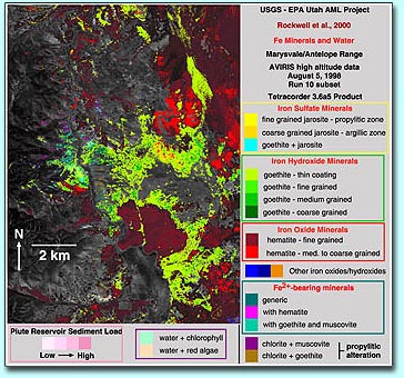
This is an example of research conducted by the United States Geological Survey using AVIRIS data. The image is an Fe(Iron)-bearing mineral map (0.35 to 1.35 micron spectral region) in the Antelope Range derived from Tetracorder analysis of AVIRIS data. (Please refer to this AVIRIS Workshop paper for more information regarding the above mineral map.)
Subject:
Instrument: