This site requires that JavaScripts be enabled in your browser. For instructions,
click here
Skip to main content
NASA - National Aeronautics and Space Administration
You must have JavaScript enabled to use this form.
›
Log in to ORACLES
|
›
Create New Account
Log in to ORACLES
Username
*
Password
*
Create new account
Request new password
Search form
Search
Leave this field blank
ESPO
Missions
About ESPO
Video about ESPO
Services
Deployment Sites
Aircraft
Satellites
Links
ESPO Archive
Browse
Help
Flight Request
Mission Tools
ASP Mission Tool Suite
ORACLES Home
ARM Blog by Paquita Zuidema
ORACLES Results Publications
ORACLES Background Publications
Mission Planning
Upload Schedule
Mission Calendar
Daily Schedule
RSS Feed
Daily Forecast
Science
Science Reports
Two-page ORACLES Flyer
ORACLES Science Overview
Coordinated Missions
Science Objective Planning
Instrument summaries V5
Instrument sampling considerations V5
Model-observation comparisons
Data Archive
ORACLES-1
ER-2
P-3 Orion
ORACLES-2
P-3 Orion
ORACLES-3
P-3 Orion
Science Meetings
2020 Science Team Meeting
2019 Science Meeting
ARC 2018 Science Meeting
STM 2018 Agenda DRAFT
Logistics
Shipping
Orientation Document
All Hands Presentation
Google Map São Tomé
Medical Evacuation Insurance
São Tomé
Point of Contact (POC)
ANF - Contractor
Lodging
Pestana São Tomé Hotel Form
HTSOS Training
Pestana São Tomé Hotel Form
Sao Tome To-do Checklist
Barbados
Cabo Verde
Location Details
WFF
WFF Lodging
Disclosure Form
Medical Clearance for P3 Flyers
WFF Safety Brief
WFF Car Rental Returns
NPR 1800.1D Chapter 2
2018 P-3 Seating Charts
SSAI Travel Instructions
Platforms
Airborne
Instruments
Participants
Links
News
Science
ICARE Cloud-Aerosol-Water-Radiation Interactions
Mission Tools Suite
Ground-Based Instruments
AERONET-Maritime Aerosol Network for ORACLES
KMZ
TXT
e-MAS data
e-MAS data quick looks example
SatCORPS
MODIS above-cloud aerosol retrievals images
CALIOP/ CATS curtain plots
Flight tracks 2016
Both Planes JPEG
P-3 KML
ER-2 KML
Flight tracks 2017
JPEG
P-3 KML
Flight tracks 2018
JPEG
P-3 KML
Travel Links
Shared Files
Photos
Aircraft
Instrument
People
Data
Education and Outreach
Other
Videos
ORACLES 2018
ER-2
Safety
Forecasting
ORACLES
Home
> Aircraft
Photo primarily shows an aircraft (or other platform)
Synonyms:
Platform
P-3B taxi in at Ellington Field upon completion of DISCOVER-AQ Data Flight #1
Read more
about P-3B taxi in at Ellington Field upon completion of DISCOVER-AQ Data Flight #1
Figure 2: Altitude vs time plot for science flight #9, September 2, 2013.
Read more
about Figure 2: Altitude vs time plot for science flight #9, September 2, 2013.
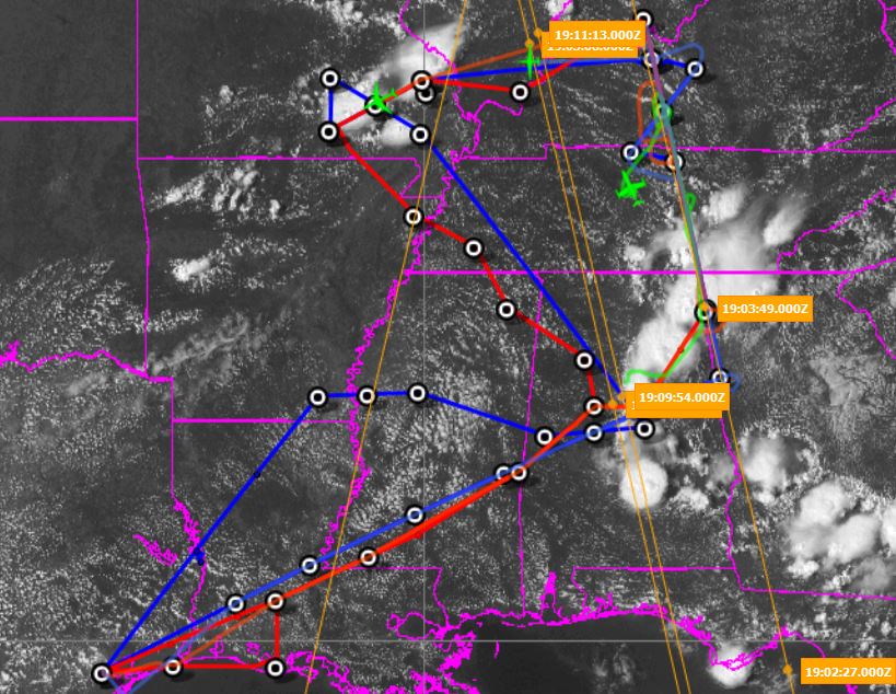
Figure1: Flight tracks of ER-2 (blue), DC-8 (red), SPEC LearJet (yellow) for ER-2 science flight #9, September 2, 2013, overlaid on MODIS-Aqua visible image at 19:30UT.
Read more
about Figure1: Flight tracks of ER-2 (blue), DC-8 (red), SPEC LearJet (yellow) for ER-2 science flight #9, September 2, 2013, overlaid on MODIS-Aqua visible image at 19:30UT.
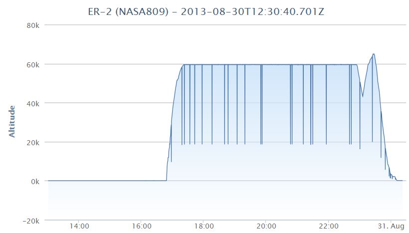
Figure2: Altitude vs time plot for science flight #8, August 30, 2013.
Read more
about Figure2: Altitude vs time plot for science flight #8, August 30, 2013.
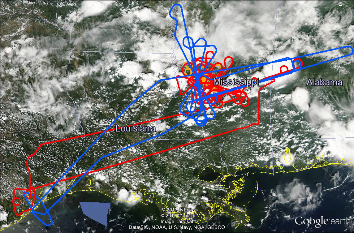
Figure1: Flight tracks (planned and flown) of ER-2 (blue) and DC-8 (red) for ER-2 science flight #8, August 30, 2013 overlaid on GOES visible image at ~20:30UT.
Read more
about Figure1: Flight tracks (planned and flown) of ER-2 (blue) and DC-8 (red) for ER-2 science flight #8, August 30, 2013 overlaid on GOES visible image at ~20:30UT.
AV-6 landing from T-34 viewpoint (8.30.13)
Read more
about AV-6 landing from T-34 viewpoint (8.30.13)
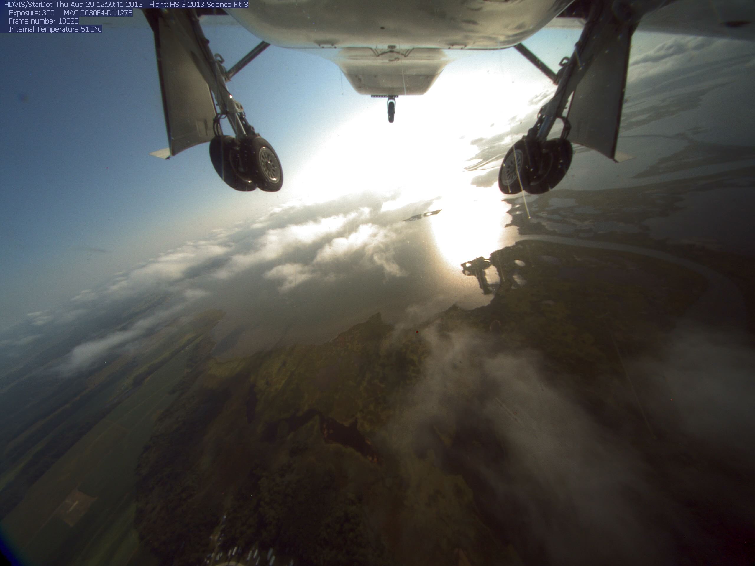
AV-6 Takeoff - Science Flight #3 (8.29.13)
Read more
about AV-6 Takeoff - Science Flight #3 (8.29.13)
ER-2 Overflight
Read more
about ER-2 Overflight
ER-2 Ellington Overflight
Read more
about ER-2 Ellington Overflight
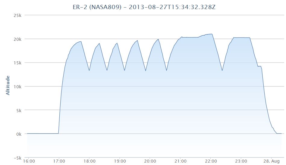
Figure2: Altitude vs time plot for science flight #7, August 27, 2013.
Read more
about Figure2: Altitude vs time plot for science flight #7, August 27, 2013.
Pages
« first
‹ previous
…
85
86
87
88
89
90
91
92
93
…
next ›
last »